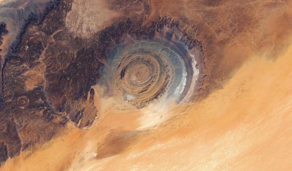
NASA brings new data to light about the Richat Structure, the globally known “Eye of the Sahara.” Despite its perfect circular shape that suggests a meteorite impact, scientists confirm that it is a purely terrestrial formation. The phenomenon, which spans approximately 40 kilometers, is the product of complex geological movements. As NASA notes, the variations in size measurements simply underscore the organic and “imperfect” beauty of natural geometry.
Read: NASA: The Roman telescope prepares to open new window to the Universe
From the very first manned space missions, the “Eye of the Sahara” served as a “beacon” for astronauts, as it stands out like a landmark in the otherwise uniform desert. Although its perfect circular shape fueled the meteorite impact scenario for decades, the geological reality is different. It is an impressive “geological dome” that resulted from the uplift and gradual erosion of the ground. The secret of its origin lies in the arrangement of the rocks. The oldest are found in the “pupil” of the eye and the newer ones in the outer rings.
Is it Earth or is it Mars? 🪐
This striking view is actually the Richat Structure in Mauritania—also known as the “Eye of the Sahara”—a massive, 25-mile-wide geologic formation shaped by erosion and visible from space. pic.twitter.com/YcfoEHFEdE
— AccuWeather (@accuweather) April 23, 2026
How the circular formations were created
The secret of the concentric circles lies in “differential erosion.” As different types of rocks exhibit different resistance levels, time and the elements of nature “carved” the ground, leaving the harder layers to protrude as circular ridges. The impressive hues captured by the lens are not random, but constitute a geological map that depicts the mixture of sedimentary and igneous rocks.
The Eye of the Sahara: A Monumental Testimony to the Global Flood
Visible from space as a massive, spiraling bullseye in the western Sahara, the Eye of the Sahara—also called the Richat Structure—stands as one of Earth’s most striking landforms. Spanning 25–31 miles across,… pic.twitter.com/9pWQhifxet
— ArchaeoHistories (@histories_arch) April 2, 2026
Around the “Eye,” the desert tells its own story through sand dunes. NASA identifies both linear and transverse sand dunes, which form according to the whims of the wind, creating unique patterns as sand collides with rocks or gets trapped in natural obstacles.
Breathtaking view from space of the Richat Structure, famously known as the Eye of the Sahara.
(Credit: NASA/METI/AIST/Japan Space Systems, and U.S./Japan ASTER Science Team) pic.twitter.com/n88102n4nV
— World and Science (@WorldAndScience) March 11, 2026
The Sahara affects the entire planet
Beyond its geological significance, the Sahara functions as a giant “mechanic” of global climate and ecosystem. The winds that shape the sand dunes can carry enormous amounts of dust into the atmosphere. According to NASA data, approximately 182 million tons of dust are lifted annually from the Sahara. Of these, about 27.7 million tons end up in the Amazon basin, providing approximately 22,000 tons of phosphorus that enhance soil fertility.
🟥 ⛏️ The Richat Structure
often called the Eye of the Sahara, is a prominent geological feature in the Adrar Plateau of Mauritania’s Sahara Desert.🔁 ❤️#RichatStructure #EyeOfSahara… pic.twitter.com/zPvhZog1Z9
— Geology Bits of Knowledge (@geologyBits) January 7, 2026
Meanwhile, NOAA describes the phenomenon of the “Saharan Air Layer,” a mass of dry and dusty air that can travel thousands of kilometers, affecting weather, visibility and even tropical storm development. The Richat Structure thus represents a characteristic example of how an impressive geological formation can have a much more complex and long-term history than appears at first glance. At the same time, it reminds us that deserts are not “dead” places, but dynamic systems that affect the entire planet.