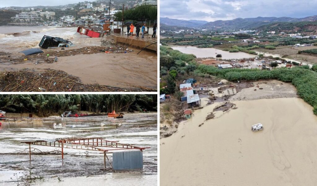
Today is shaping up to be another grueling day for Crete, as the severe storm continues to batter the island with no signs of letting up. Earlier, emergency alerts were sent to mobile phones across Crete, with Civil Protection authorities warning residents about dangerous weather conditions and urging them to limit travel to absolutely essential trips only. “Severe weather events are expected in the Region of Crete from the evening of Friday, October 2nd, through the afternoon of Saturday, October 3rd. Limit your movements to absolutely necessary ones. Follow the instructions of the Authorities.”
Read more: Weather warning: Expert raises alarm over storm, Crete to be severely hit — up to 500 tonnes of water per acre by Monday (Video)
Crete: Record rainfall levels and elevated flood risk
Particular concern is being raised about conditions across mainland Crete, where the ground is already heavily saturated from relentless rainfall. According to forecasts, extremely high precipitation levels are expected through the early hours of Saturday, with the heaviest impact falling on mountainous and semi-mountainous areas such as Anogia, Zoniana, and the Lasithi Plateau.
The fact that the ground has already reached saturation point significantly increases the risk of flash flooding, as every additional rainfall worsens the situation further. For this reason, heightened caution is required — particularly in areas with steep terrain, near streams and torrents, and in locations with a history of landslides or water accumulation.
Guidelines issued by the Region of Crete for severe weather conditions
The Region of Crete had earlier issued guidelines urging citizens to exercise extreme caution.
In its official announcement, it stated:
“The Civil Protection of the Region of Crete announces that all Civil Protection Mechanism Services have been placed on Red Code mobilization status, as — according to the update (02-10-2026/1200 C) of Emergency Bulletin No. 6/2026 for Dangerous Weather Phenomena issued by the Hellenic National Meteorological Service (HNMS) — dangerous weather conditions at Red Warning level continue across Crete today, Friday (02-10-2026), and primarily on Saturday (03-10-2026), with the following key features:
a) Locally intense rainfall and thunderstorms
b) Very strong north-northeasterly gale-force winds
By decision of the Governor of Crete, passage through, lingering in, and movement within high-risk areas is prohibited:
• Gorges (monitored and unmonitored)
• Nature trails
• Hiking/mountaineering routes (E4 or otherwise)
• Other ecosystems in areas of steep relief
It is noted that in Heraklion, due to the approaching storm, the road from Silamos to Archanes has been closed from both directions.
Citizens are advised to avoid unnecessary travel, to exercise extreme caution in areas where severe weather is occurring, and to follow the instructions of the Authorities for their own safety. Additionally, it is recommended to consider postponing or cancelling any outdoor sporting, religious, or cultural events.
In summary:
THUNDERSTORMS – FLOODING
In the event of a flood risk, evacuate basements, coastal areas, streams, and torrents in a timely manner. Modify your plans and under no circumstances travel by vehicle or on foot during the peak of the weather events.
GALE-FORCE WINDS
When gale-force winds occur, avoid activities in marine and coastal areas as well as in open countryside.”
Fire service mobilization remains at full strength, with crews focused on providing assistance wherever needed and managing weather-related incidents. Firefighters are on heightened readiness for water pumping operations, tree removal, and the safe evacuation of citizens to secure locations where necessary.

Emergency 112 alert issued for Mylopotamos on Friday afternoon
It is worth noting that at 4:29 PM, another emergency 112 alert was issued, advising residents to limit movement across the wider area of the Municipality of Mylopotamos in Rethymno.
The new, island-wide warning makes clear that authorities are on heightened alert ahead of the next deterioration in conditions.
With weather events already underway and a fresh, powerful wave of rainfall expected from Friday evening, Civil Protection is urging citizens to minimize unnecessary travel and to follow all official guidance.
Major concern in Zoniana — torrent overflows its banks
Meanwhile, as reported by neakriti.gr, residents of Zoniana are living through their second consecutive day of anguish, as the new storm system battering Crete strikes the mountainous Mylopotamos area with particular ferocity, piling further pressure on the already-stricken village. The local torrent has overflowed its banks, while residents describe today’s situation as even worse than what they faced the day before.
The intensity of the conditions is causing widespread alarm. The village, which had already been tested by the heavy rainfall and damage left in the wake of the storm’s first wave, is now facing a second onslaught — with rushing floodwaters having entered homes.
Residents are in despair as, for the second day running, massive volumes of water are cascading through the area with tremendous force, while the severe weather shows no sign of easing.
Reports from the area confirm that the torrent has burst its banks, with locals describing conditions today as even worse than those they endured the previous day.
Crete faces critical hours ahead
Crete has been at the mercy of the storm since Thursday, with severe weather events causing a cascade of problems across numerous areas of the island. The human toll so far is tragic: one livestock farmer has lost his life in Rethymno. Flooded roads, overflowing waterways, landslides, and debris flows have triggered a full Civil Protection response across the island, as heavy rainfall continues unabated.
Updated emergency bulletin issued by the Hellenic National Meteorological Service
Heavy rainfall and thunderstorms are forecast for today, Friday (02-10-2026), through to midday on Sunday (04-10-2026) across the southern Aegean, while locally very strong northeasterly winds of up to 8 to 9 Beaufort will blow across the Aegean from today, Friday (02-10-2026), through to the afternoon of Saturday (03-10-2026), according to the updated severe weather bulletin issued by the Hellenic National Meteorological Service (HNMS).
More specifically, locally intense rainfall and thunderstorms are forecast across Crete from late afternoon on Friday, and primarily throughout Saturday. From Saturday evening, a gradual weakening of the weather events is expected.
In the Dodecanese, heavy rainfall and thunderstorms are forecast from midday on Saturday through to midday on Sunday.
At the same time, locally very strong northeasterly winds, reaching 8 to 9 Beaufort, will be blowing across the Aegean today, Friday, and through to the afternoon of Saturday.
Lasithi: Incalculable damage to potato and vegetable crops
The destruction wrought by the storm on the Lasithi Plateau has been total. The plain has been transformed into a vast lake, with potato and vegetable crops entirely wiped out.
At the same time, a large part of the Plateau — the entire northern side — remains without power. This includes the municipal hall itself, with crews from the Hellenic Electricity Distribution Network Operator (HEDNO) having been fighting a Herculean battle since yesterday to restore damage and bring electricity back to affected areas.
Massive water volumes force opening of Aposelemis dam floodgate
Full-scale water management operations are now underway to deal with the enormous quantities of water that have accumulated across the Plateau area. The floodgate at the Aposelemis dam has been opened, while the Chavgas torrent is discharging approximately 700,000 cubic metres of water, according to the latest available information. The accumulation of such vast volumes of water is creating serious problems, with the situation being closely monitored by the competent authorities.
So far, total rainfall has reached 250 millimetres, while in Tzermiado the cumulative rainfall figure for 2026 has climbed to 1,280 millimetres — a stark reflection of the extraordinary intensity of the weather events afflicting the region.
Water supply disruptions in Heraklion
The Fortezza and Agia Triada districts have been grappling with mounting water supply problems over recent days, as a series of pipe and borehole failures — compounded by repeated power outages — have severely disrupted the normal water supply to both areas.
Speaking to Cretalive, the president of the Heraklion Municipal Water and Sewage Company (DEYAH), Giorgos Vourexakis, explained that the situation in Fortezza has deteriorated significantly over the past week, with one failure following another in rapid succession.
One of the most critical problems involves the main pipeline carrying water from Thrapsano, which has sustained damage. Additionally, issues have emerged with boreholes in the area, further reducing the available water supply.
Illustrating just how serious the situation has become, only one of the three boreholes in Thrapsano is currently operational. Meanwhile, power cuts experienced both yesterday and today have compounded the situation further, impacting the functioning of facilities and hampering restoration efforts.
In an effort to boost the water supply to Fortezza, DEYAH is working to channel water from the Vasileies area, in order to reduce the problems and the hardship being experienced by residents as much as possible.
“We are facing continuous failures and are doing our best to address the problems as they arise,” said Mr. Vourexakis, describing the difficulties created by the combination of network damage and power outages.
A separate problem has also emerged in Agia Triada, where a burst pipe has been identified. DEYAH crews have already begun repair work. According to the company’s president, the area did have water supply today, though it was being delivered at low pressure due to the pipe damage affecting normal distribution.
Repair crews continue their work with the aim of restoring the damage and returning water supply to normal levels across both areas.
Flooding in central Heraklion
The centre of Heraklion has been flooded, with photographs published by Cretalive.gr showing pools of water forming along the edge of the roadway at the entrance to Georgiadi Park.
“The images reflect a serious problem with stormwater management in the city. As is clearly visible, a large section of the road has been submerged, with parked cars and motorcycles sitting in the water and movement for both pedestrians and vehicles severely hampered,” one resident told the local outlet, raising the direct question of whether “the existing drainage infrastructure and flood-prevention measures are adequate to protect citizens and their property.”

Official safety guidelines from the General Secretariat for Civil Protection
The General Secretariat for Civil Protection (www.civilprotection.gr), operating under the Ministry of Citizen Protection, has notified all relevant government agencies, as well as regional and municipal authorities across the country, to maintain heightened Civil Protection readiness in order to respond immediately to the impact of severe weather events.
At the same time, the General Secretariat for Civil Protection is advising citizens to exercise extreme caution and to take all necessary self-protection measures against the risks posed by severe weather events.
Thunderstorms
Specifically, in areas where heavy rainfall