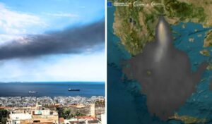
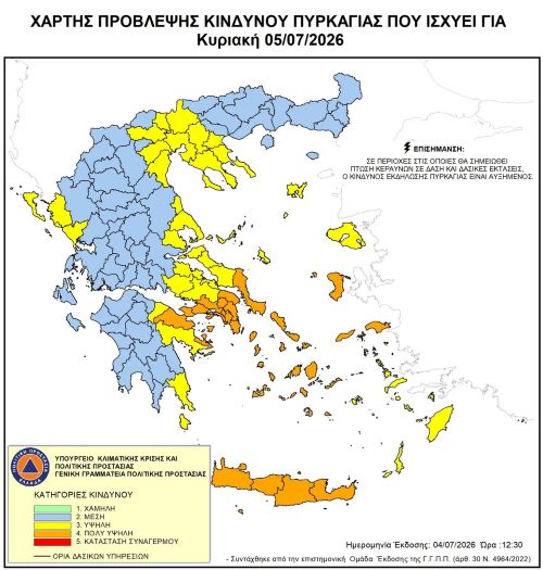
The weather forecast and ongoing wildfires across various parts of Greece have triggered an orange alert for six regions on Sunday, July 5, according to the Fire Risk Forecast Map issued by the General Secretariat for Civil Protection of the Ministry of Climate Crisis & Civil Protection (civilprotection.gov.gr). Among the six high-risk regions is Attica, meaning all relevant state services will be on standby to prevent the worst-case scenarios.
Which are the six high-risk regions?
Specifically, according to the Fire Risk Forecast Map issued by the General Secretariat for Civil Protection of the Ministry of Climate Crisis & Civil Protection (civilprotection.gov.gr), a very high fire risk (risk category 4) has been forecast for Sunday, July 5, 2026, in the following areas:
* Region of Attica
* Region of Peloponnese (Regional Unit of Corinthia)
* Region of Central Greece (Regional Unit of Euboea)
* Region of North Aegean (Regional Units of Chios, Samos, and Ikaria)
* Region of South Aegean (Cyclades)
* Region of Crete
The General Secretariat for Civil Protection (civilprotection.gov.gr) of the Ministry of Climate Crisis & Civil Protection has notified all relevant state agencies, as well as the regional and municipal authorities of the affected areas, to remain on heightened civil protection alert and respond immediately to any wildfire incidents.
At the same time, the General Secretariat for Civil Protection is urging citizens to exercise extreme caution and avoid any outdoor activities that could accidentally start a fire — such as burning dry grass and branches or garden waste, using spark-generating equipment like angle grinders or welding devices, using outdoor barbecue grills, smoking beehives, or discarding lit cigarettes. It is also a reminder that burning of fields is prohibited during the fire season.
If citizens spot a wildfire, they are asked to immediately notify the Fire Service by calling 199.
For more information and self-protection guidelines regarding the risks of forest fires, citizens can visit the General Secretariat for Civil Protection’s official website at civilprotection.gov.gr.
Weather forecast for Sunday, July 5
In its forecast for Sunday, the Hellenic National Meteorological Service (EMY) is warning of strong northerly winds in the Aegean, locally reaching up to 8 Beaufort during the midday and afternoon hours.
GENERAL OVERVIEW
Central Macedonia (mainly Chalkidiki), eastern Thessaly, the Sporades, Euboea, and eastern Central Greece will see temporary cloud cover with localized rainfall and possibly isolated thunderstorms, with conditions improving by the afternoon. The rest of the country will enjoy generally clear skies with brief cloudy spells around midday and the afternoon, when localized rainfall or showers are expected in Thrace, the Peloponnese, western Central Greece, and the southern Ionian Sea — with isolated thunderstorms possible in the Peloponnese.
Winds will blow from northerly directions at 5 to 7 Beaufort, with temporary local gusts reaching 8 Beaufort in the Aegean.
Temperatures will drop slightly further in the north and east, not exceeding 33 to 34 degrees Celsius.
MACEDONIA & THRACE
Weather: Central Macedonia (mainly Chalkidiki) and gradually Thrace will see temporary increased cloud cover with localized rain — initially in Central Macedonia and by midday to afternoon in Thrace, with possibly isolated thunderstorms. Other areas will have near-clear skies with few brief cloudy spells.
Winds: Northerly at 3 to 5 Beaufort, gradually becoming variable at 3 to 4 Beaufort.
Temperature: 20 to 33°C. In western Macedonia, 3 to 4 degrees lower.
IONIAN ISLANDS, EPIRUS, WESTERN CENTRAL GREECE & WESTERN PELOPONNESE
Weather: Generally clear skies. Around midday to afternoon, western Central Greece, western Peloponnese, and the southern Ionian will see temporary cloud cover with localized rain or showers, and isolated thunderstorms in the western Peloponnese.
Winds: Northeasterly at 3 to 5 Beaufort, with northwesterly winds of 5 to 6 Beaufort in the northern Ionian from the afternoon.
Temperature: 21 to 32°C, up to 34°C inland. In the interior of Epirus, 2 to 3 degrees lower.
THESSALY, EASTERN CENTRAL GREECE, EUBOEA & EASTERN PELOPONNESE
Weather: Eastern Thessaly, the Sporades, Euboea, and eastern Central Greece will see temporary heavy cloud cover with localized rain and possibly isolated thunderstorms, improving by the afternoon. Other areas will be generally clear with brief localized cloudy spells around midday and afternoon, with localized rain or isolated thunderstorms expected in the eastern Peloponnese.
Winds: North to northeasterly at 3 to 5 Beaufort, locally reaching 6 Beaufort in the east.
Temperature: 21 to 33°C.
CYCLADES & CRETE
Weather: Generally clear with few brief cloudy spells, mainly around midday to afternoon in Crete, where localized showers are possible in mountainous areas.
Winds: Northerly at 5 to 7 Beaufort, possibly reaching 8 Beaufort locally in the Cyclades around midday to afternoon.
Temperature: 23 to 29°C, up to 32°C in Crete.
EASTERN AEGEAN ISLANDS & DODECANESE
Weather: Generally clear with few brief cloudy spells, mainly around midday to afternoon.
Winds: Northerly at 5 to 7 Beaufort, possibly reaching 8 Beaufort locally around midday to afternoon.
Temperature: 24 to 33°C.
ATTICA
Weather: Generally clear skies with few brief cloudy spells around midday to afternoon.
Winds: North to northeasterly at 4 to 6 Beaufort, with temporary local gusts of 7 Beaufort in eastern areas.
Temperature: 23 to 32°C.
THESSALONIKI
Weather: Generally clear skies with few brief cloudy spells around midday to afternoon.
Winds: Initially northwesterly at 4 to 5 Beaufort, gradually becoming variable at 3 to 4 Beaufort.
Temperature: 21 to 32°C.