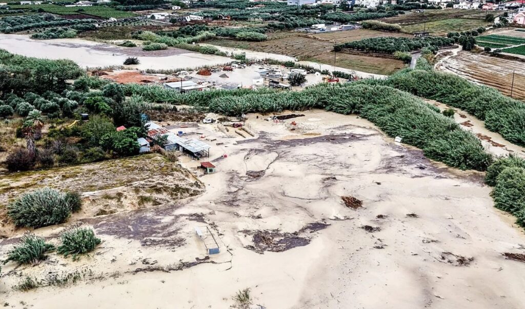
The fierce storm system that battered Crete appears to be taking a brief pause, with heavy rainfall expected to return from Friday afternoon. According to the latest forecast data from the National Observatory of Athens / meteo.gr, the new round of intense weather will primarily affect the northern and mountainous parts of the island and is expected to last through Sunday afternoon. Given the hundreds of tonnes of water that have already fallen on Crete, the ground has reached saturation point, making the risk of new flooding particularly serious.
Where rain and thunderstorms are expected — Strong northerly winds persist
Rain and thunderstorms are also expected across Euboea and the Dodecanese, while fewer weather events are anticipated in Eastern Central Greece, the Eastern Peloponnese, the Sporades, and the Cyclades. At the same time, powerful northerly winds continue to batter the Aegean, reaching eight Beaufort with gusts exceeding 100 kilometres per hour. These are expected to begin easing from Sunday onwards. Weather conditions will start improving gradually from Monday, though temperatures will remain low for a few more days.
Saturday is the day that will require the most caution
According to the Hellenic National Meteorological Service (EMY), the greatest concern regarding Crete is focused on areas in the western part of the island, with heavy rainfall expected to affect mainly Chania and Rethymno. Saturday is forecast to be the most critical day of this new weather phase. Meanwhile, intense weather phenomena are also expected to affect the broader southern Aegean region, with conditions remaining challenging due to the combination of heavy rainfall and strong winds.
Highlighting the severity of conditions, northeasterly winds will reach 8 to 9 Beaufort locally, with EMY having issued warnings for a number of maritime areas. At the Kafireas Strait and parts of the central Aegean, winds are reaching 8 to 9 Beaufort, while stormy conditions are also being recorded in the Sea of Crete and other maritime areas.
Kolydas: The four regions where storms will strike before the week is out
In a post on X, former EMY director Thodoris Kolydas warned that the storm system, accompanied by heavy rainfall, will intensify in the coming days — particularly over the Peloponnese, Kythira, Crete, and the Southern Aegean. According to the meteorologist, the upper atmosphere is playing a decisive role in the development of this severe weather event, noting that an organised low-pressure system at 500 hPa is deepening and increasingly affecting the eastern Mediterranean.
“Today’s update confirms that the main weather focus is gradually shifting towards southern Greece, where rainfall is expected to intensify over the coming days, particularly in the Peloponnese, Kythira, Crete, and the Southern Aegean. This development is not solely due to the familiar northerly current channelling colder air masses towards the Aegean.
The upper atmosphere is playing a decisive role, as an organised low at 500 hPa continues to deepen and exert a growing influence over the eastern Mediterranean. Its presence is reinforcing upward air movement, dynamic instability, and convergence, allowing the weather phenomena to gain greater intensity and duration.
As a result, a more complex and dynamically supported weather pattern is forming across the south, with an increased likelihood of strong and persistent rainfall — mainly from Friday through to Saturday,” he wrote in his post.
EMY: Weather forecast for Friday
Cloudy skies with localised rain and thunderstorms are expected across central and southern mainland Greece, Euboea, and the Southern Aegean. Weather phenomena in Crete will be locally intense from the afternoon, while conditions in Euboea may also be intense around midday.
Elsewhere in the country, weather will be generally clear with temporarily increased cloud cover in Thrace. Winds in the west will blow from northerly directions at 4 to 5 Beaufort, locally reaching 6, while in the east, northerly winds will reach 6 to 8 Beaufort, with local gusts of 9 Beaufort across the Aegean.