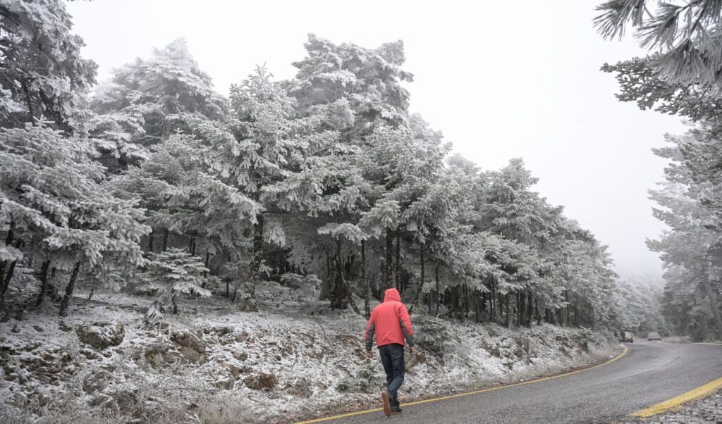
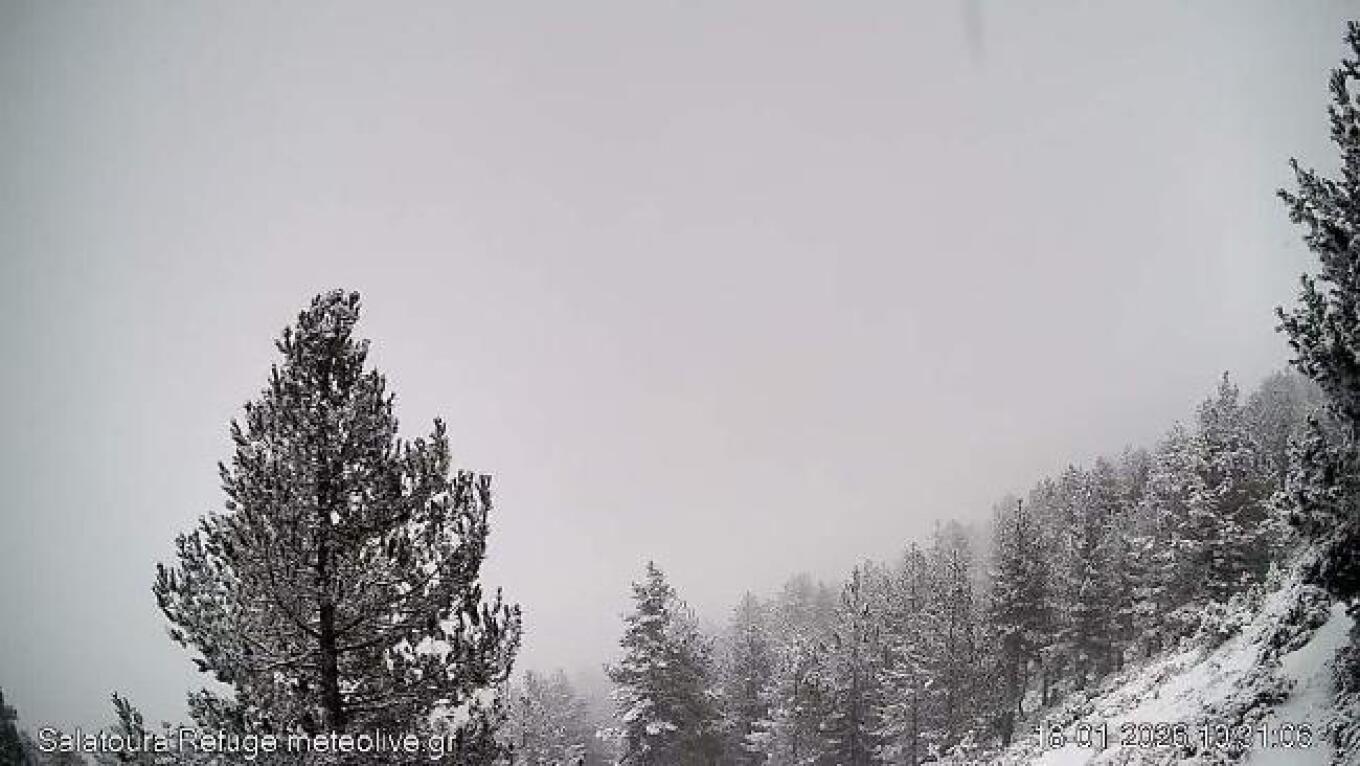
Winter has made its entrance, with temperatures significantly low and the first snow already appearing. Polar cold prevails across the country while Wednesday (21/01) is expected to bring a rapid deterioration of the weather.
Read: Weather almanac 2026: detailed forecast for the entire year
Weather: meteorologist Klearchos Marousakis explains the Aegean sea effect phenomenon and provides detailed forecasts for the bad weather
Polar cold conditions have prevailed in recent days throughout the country, affected by the “Aegean Sea Effect” phenomenon. As meteorologist Klearchos Marousakis explained, the polar air mass that has visited our region is quite dry and requires moisture quantities to produce weather phenomena, which it draws from the Aegean Sea. The “Aegean Sea Effect” phenomenon refers to various phenomena, mainly the decisive role of the sea in regional climate (such as strong winds, meltemia and humidity), its impact on marine ecosystems (which are threatened by tourism and climate change), as well as a special local meteorological phenomenon (the “Aegean Lake Effect”) that causes snowfall in winter in areas near the coasts.
It also includes important hydrological processes (formation of water masses) that affect the entire Mediterranean, as well as impacts from sea level rise and seismic activity (tsunamis), which shape the environment and history of the region. Frost occurred on Monday morning 19/01 in several mainland areas, while frost was locally strong in northern Greece. The lowest minimum temperature was recorded at the Dragati Rodopi Shelter with -13.4 °C. The map in the following image shows the geographical distribution of minimum temperature, as well as the 8 stations that recorded the lowest values.

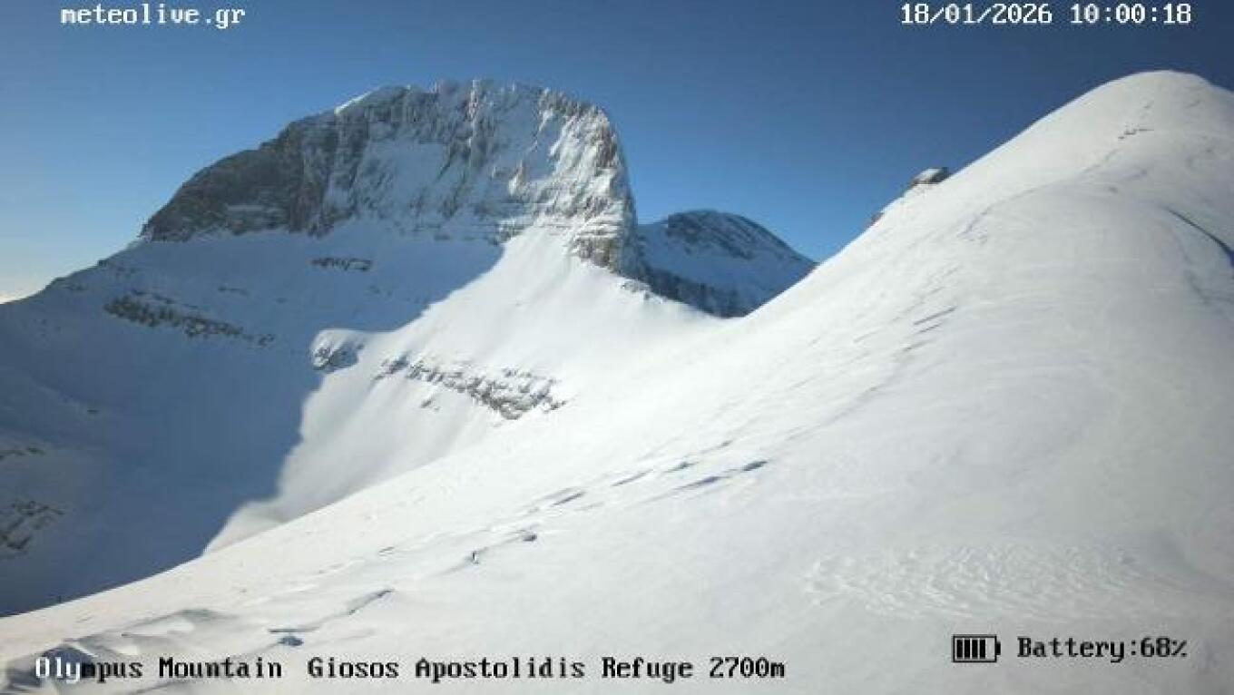
Weather: the paradoxical phenomenon on Mount Olympus
A cold invasion is underway in our country, with many low-altitude areas receiving snowfall in Northern and Central Greece. However, a particularly impressive and seemingly paradoxical phenomenon is observed in our country: while snowfall is recorded at low and medium altitudes, even below 500 meters altitude, at the highest peaks of Olympus the weather is clear, with sunshine. Characteristic are the images from the Plateau of the Muses and the weather camera of meteolive.gr, at an altitude of about 2700 meters, where absolute clarity prevails, in complete contrast to the conditions of heavy snowfall recorded at the same time at lower altitudes.
This phenomenon is not rare in meteorology and can be fully explained if we examine the vertical structure of the atmosphere, as depicted in the radiosonde from Thessaloniki at 02:00 in the morning of January 18th. The radiosonde shows that above approximately 2300–2700 meters altitude the atmosphere was extremely dry, with only 9% relative humidity. This means that in the upper layers there was downward air movement, which dries the atmosphere and dissolves clouds. Conversely, in the lower layers of the troposphere (below 1500 m) the atmosphere was saturated, with relative humidity close to 100%, favoring the creation of extensive cloudiness and snowfall. It should be noted that weather forecast models successfully predicted the phenomenon. Similar weather conditions prevailed on Saturday 17/01, when the Sentinel-2 satellite saw the snowy peaks of Olympus above the clouds.

Today’s weather
In the central eastern and southern mainland areas and in Euboea, local rains will occur, while weak snowfall will mainly occur in mountainous and semi-mountainous parts. In Macedonia (mainly in central and western parts) and in Thessaly, weak snowfall is expected locally and periodically, even in lowland areas. Local rains are also expected in parts of the Cyclades and Crete, while temporary snowfall will occur in the mountains of Crete.
Temperature will range in Western Macedonia from -8 to 1 degree, in the rest of Macedonia from -4 to 4, in Thrace from -8 to 3-4, in Epirus from -2 to 8 degrees, in central mainland from -2 to 4-6, in western and southern mainland from 3 to 8-10 degrees, in the remaining eastern mainland from 0 to 7 degrees, in the Ionian Islands from 4 to 8-10, in the islands of the Northern and Northeastern Aegean from 0 to 6-7 degrees and in the remaining island parts of the Aegean and Crete from 4 to 8-11 degrees, while in the Dodecanese the maximum will reach 11-13 degrees Celsius.
In the Aegean, northeastern winds will blow with intensities 5-6 Beaufort and locally 7 Beaufort, with a strengthening trend in the evening. In the Ionian and Kythera Sea, eastern winds will blow with intensities 5-6 Beaufort, gradually strengthening to 7-8 Beaufort and from evening locally 9 Beaufort.
In Attica prefecture and Athens city we expect cloudiness with light weak rains, mainly in the northern and western parts of the prefecture. Light weak snowfall will occur periodically in mountainous areas (mainly on Parnitha and Kithaironas) and locally in semi-mountainous parts. Winds will be northeastern with intensities 5-6 Beaufort and possibly locally in the eastern areas 7 Beaufort. Temperature will range from 3 to 6-7 degrees, but in the north it will be 2-3 degrees lower.
In Thessaloniki until morning we expect cloudiness with weak snowfall in mountainous and semi-mountainous areas, as well as in low-altitude areas. In coastal areas sleet is expected and possibly temporary light snowfall. The phenomena will quickly stop and sunshine will prevail. Winds will blow from various directions with intensities 2-3 Beaufort. Temperature will range from 1 to 4-5 degrees, but around the city temperature will be 2-3 degrees lower.
Weather on Tuesday 20-01-2026
In the southern parts of central Macedonia, Thessaly, Sporades, northern Aegean islands, Euboea, eastern Sterea, Peloponnese, Ionian, Cyclades and Crete increased cloudiness with local rains and in the north rains or sleet. The phenomena in the evening will extend to the remaining mainland except eastern Macedonia and Thrace. Snowfall will occur in mainland mountainous-semi-mountainous areas, as well as in the mountains of Euboea and Crete. The phenomena will intensify in western areas during the night. In the rest of the country sparse clouds that will gradually thicken.
Winds will blow easterly northeastern, in western areas 6 to 8 and locally in southwestern areas 9, in eastern areas 5 to 6 and locally in the Aegean 7 Beaufort.
Temperature will not show significant change. In northern mainland it will reach 07 to 08 degrees, in central and southern mainland 10 to 12, in island areas and western mainland 11 to 13, while locally in Crete, Cyclades and Dodecanese it will reach 15 to 16 degrees Celsius. Frost will occur in morning and evening hours in mainland areas, which in the north will be locally strong.
Weather on Wednesday 21-01-2026
Weather deterioration with increased cloudiness and local rains throughout the country. Sporadic storms will occur in the Ionian, mainly in maritime-coastal parts of western, central and southern mainland Greece and gradually in the Cyclades, Crete, eastern Aegean islands and Dodecanese. Snowfall will occur in mainland mountainous-semi-mountainous areas, which are expected to be more intense in central and northern areas.
Winds will blow in western areas easterly southeastern 6 to 8 and in morning hours in the Ionian locally 9 Beaufort with gradual weakening. In eastern areas they will blow southeastern 6 to 8 and in the Aegean from afternoon possibly locally 9 Beaufort.
Temperature will show a small rise in the south, however frost will occur in morning and evening hours in northern mainland areas.
Weather on Thursday 22-01-2026
In western areas, Cyclades, Crete, Dodecanese and eastern Aegean islands increased cloudiness with rains and sporadic storms. In remaining areas light clouds temporarily increased with local rains. Snowfall will occur in central and northern mainland mountains.
Winds will blow southerly southwestern 4 to 6 while in morning hours southeastern 6 to 8 will prevail in Dodecanese with rapid weakening and in northern Aegean northerly 4 to 6 Beaufort.
Temperature will show a small rise in northern and central mainland areas.
Weather on Friday 23-01-2026
In western areas, southern and eastern Aegean increased cloudiness with rains and sporadic storms. In remaining areas light clouds temporarily increased with local rains mainly in central and southern areas. Snowfall will occur in northern mainland mountains.
Winds will blow southerly southwestern 4 to 5 and locally up to 6 Beaufort.
Temperature will show a small rise.
Weather: detailed forecasts by Giorgos Tsatrafyllias
Meteorologist Giorgos Tsatrafyllias warns in today’s post about flood risk (Wednesday – Thursday) in western and southern Greece, eastern Aegean, Attica, Euboea, Cyclades and Crete. In detail, as he states: “A strong low pressure system from the Tunisia area will affect our country over the next three days with potentially dangerous phenomena.
Tuesday-Wednesday
Local storms (eastern-SE winds 9-10 Beaufort) in Ionian, Peloponnese, central-western Sterea, central and southern Aegean.
Wednesday-Thursday
Strong storms and large rainfall amounts that may create flood episodes in western and southern Greece, eastern Aegean, Attica, Euboea, Cyclades, Crete.
Wednesday-Thursday
Dense snowfall, snowstorms-snow thunderstorms in all mountainous and semi-mountainous areas (central-northern).”
His complete post:
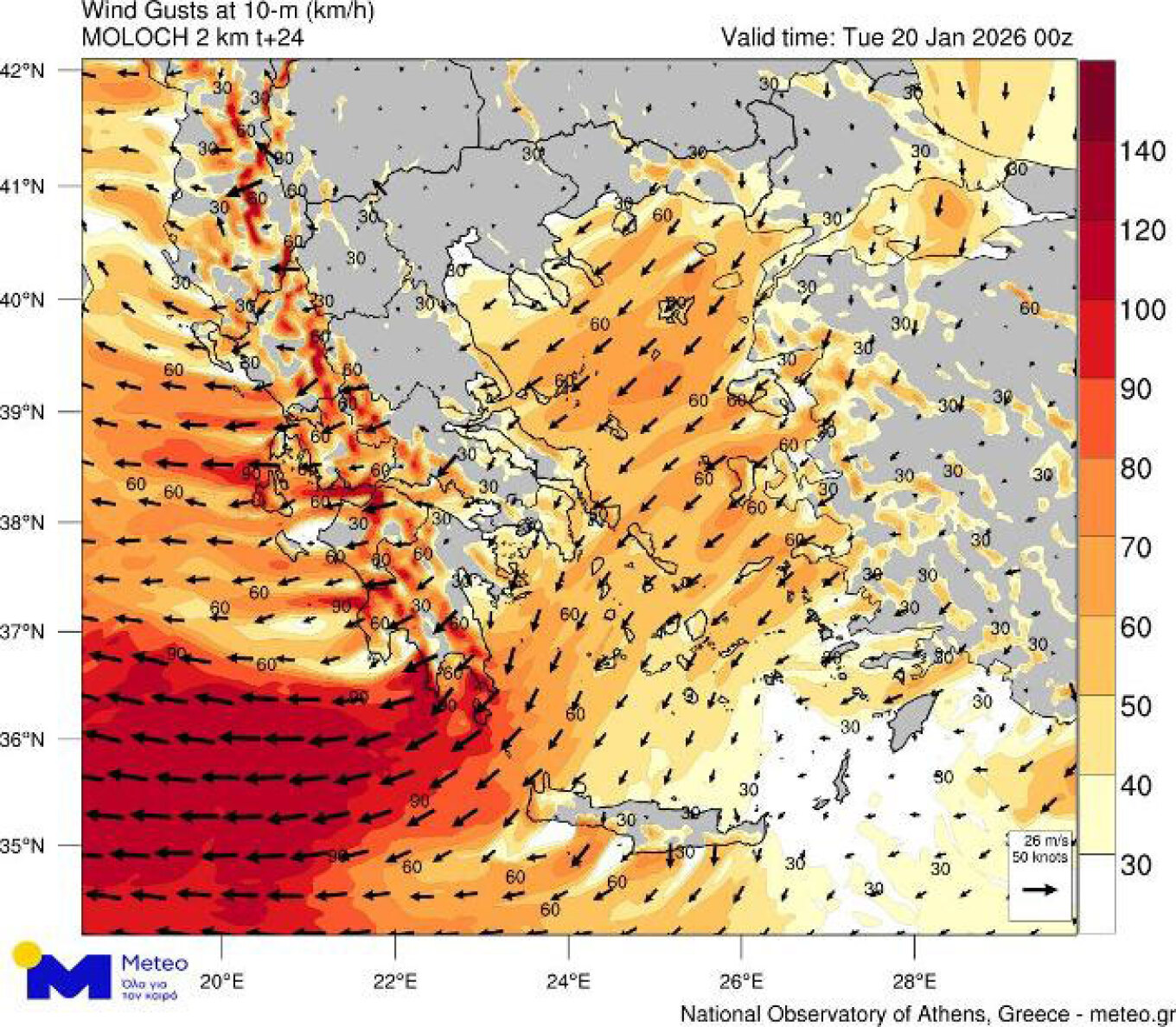
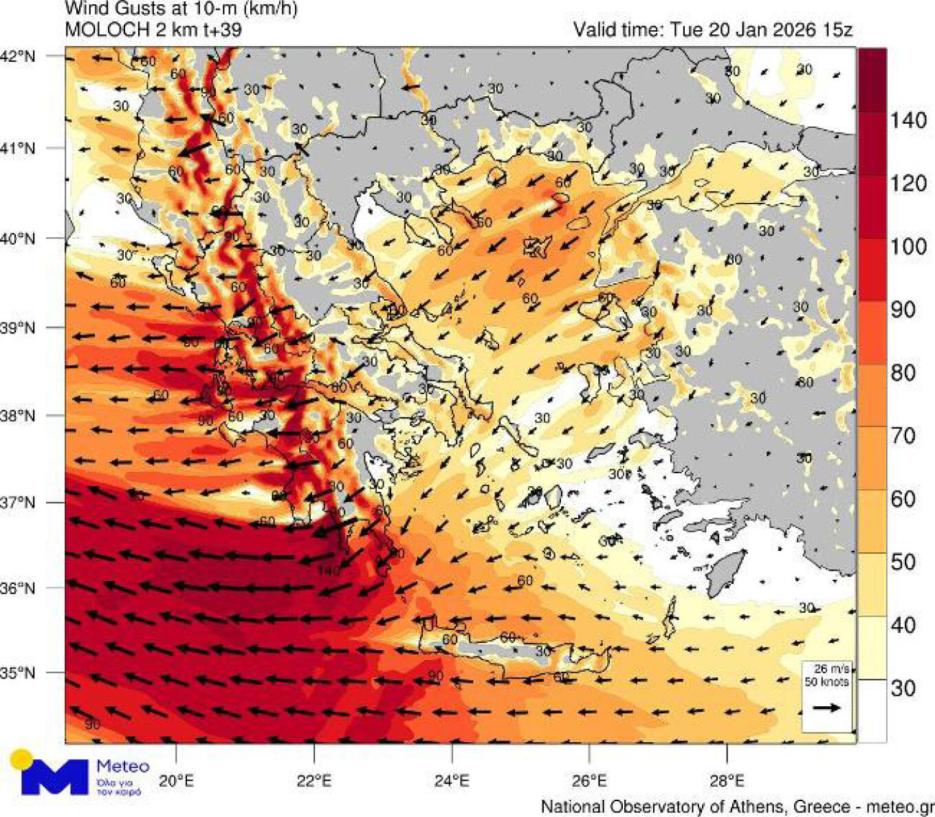
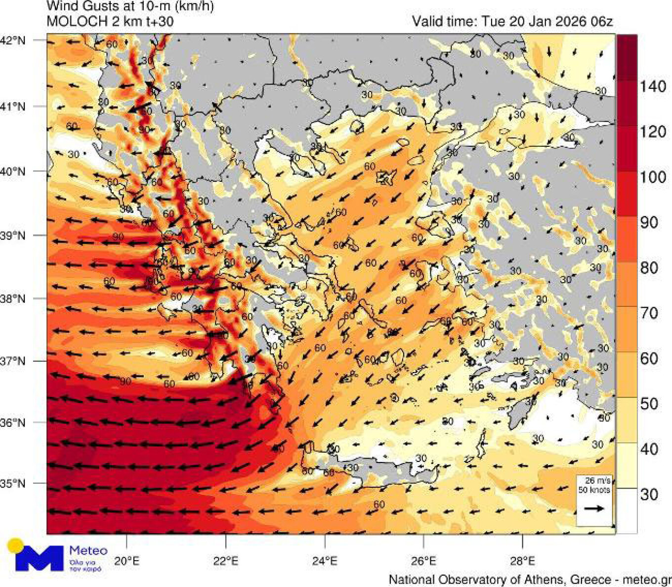
Weather: meteo.gr data
Very stormy winds on Tuesday January 20. According to forecast data from the National Observatory of Athens / meteo.gr, very stormy easterly winds are expected to prevail on Tuesday 20/01 in several areas of western and southern Greece (mean winds 8 Beaufort) and specifically in the southwest they will have storm intensities, with wind gusts that will reach locally 110 – 120km/h. The following forecast maps show the areas where we expect the strongest wind gusts during Tuesday 20/01 in early morning hours (02:00), morning hours (08:00) and afternoon hours (17:00):