Strong winds will persist through Sunday, August 16, keeping Civil Protection authorities on high alert as the risk of wildfire ignition and rapid spread remains extremely high. Four regions have been placed on Red Code emergency status, while patrols by the Fire Service, Police, and Armed Forces are being reinforced alongside aerial surveillance. A preventive ban on vehicle traffic and the presence of visitors in national parks, forests, and other vulnerable areas is also in effect.
Strong winds: The regions placed on Red Code
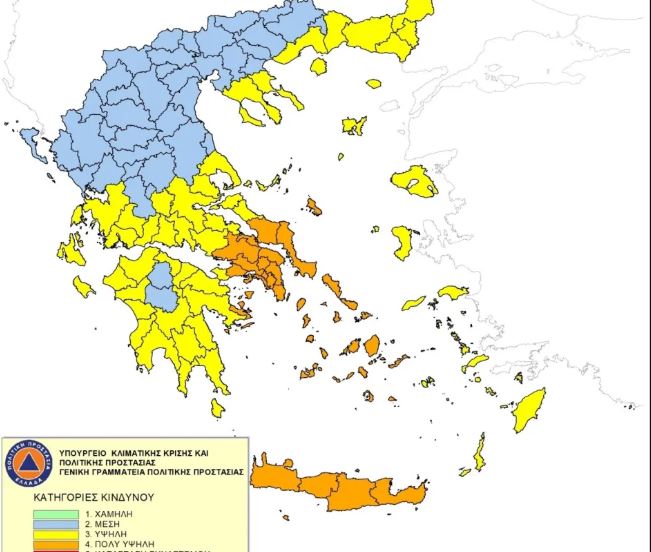
According to the Daily Fire Danger Forecast Map issued by the General Secretariat for Civil Protection, the fire risk for Sunday is classified at Category 4 — a very high level. The regions placed on Red Code include the Attica Region (including Kythira), the Regional Units of Boeotia and Euboea (along with Skyros), the Cyclades, and the Region of Crete. Red Code status requires the full mobilization of all necessary personnel and available resources to ensure an immediate and effective response to any potential emergency.
Municipalities and Regional Authorities in the affected areas are being called upon to immediately convene the relevant Local and Regional Civil Protection Coordination Bodies. At the same time, the Fire Service remains at Operational Readiness Level 2, with personnel in the affected Regional Units placed on partial standby. Civil Protection authorities are urging citizens to avoid any activity that could trigger a fire — from burning dry vegetation and using spark-generating machinery to outdoor barbecues and discarding lit cigarettes.
Strong winds with gusts exceeding 100 km/h
Meteorologist Theodoros Kolydas notes that powerful northerly winds will continue on Sunday, primarily across the Aegean Sea and its southern reaches. “The outlook for Sunday, August 16, shows that strong northerly winds are persisting, with the greatest concern remaining over the Aegean — and particularly its southern parts,” he states. Average wind intensity is forecast at around 7 Beaufort, though instantaneous gusts could be significantly stronger.
More specifically, the ICON-EU model forecasts maximum gusts of up to 129 km/h in western Crete, 113 km/h in the Kafirefs Strait, 105 km/h in southern Crete, and 104 km/h near Tinos. “The underlying situation, therefore, remains one of a strong Meltemi wind — however, the average wind speed does not justify widespread references to 8 or 9 Beaufort,” the meteorologist clarifies. He further emphasizes that “these values should be read as instantaneous peak gusts and not converted to Beaufort,” adding that “the large difference between average and gust speeds also highlights just how significant topographic acceleration can be in straits, mountain passes, and leeward areas.”
Temperatures rising — but no heatwave for now
Despite the lifting of travel restrictions and the resumption of normal ferry services, heightened caution is still required — particularly in areas where the strongest gusts are expected. A gradual rise in temperatures is forecast over the coming days; however, current meteorological data does not suggest heatwave conditions in the immediate term. In the event of a wildfire, citizens are urged to contact the Fire Service immediately by calling 199.