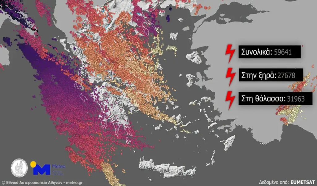
Meteo.gr has analyzed the severe weather event that struck various regions of Greece over the two-day period of Friday, July 24 and Saturday, July 25, 2026, describing it as an “unusual disturbance.” Its defining characteristic was exceptionally low temperatures in the upper troposphere — values that are rarely recorded at this time of year, according to climatological data for the region.
Read also: Storm triggers over 900 emergency calls to fire services across Attica, Central Greece and Thessaly — where the heaviest rainfall was recorded (Images & Video)
Meteo’s analysis: An unusual meteorological disturbance in the height of summer
According to Meteo.gr, cold air masses in the upper atmospheric layers triggered conditions of intense and widespread instability across the country. The disturbance followed an autumn-like pattern, resulting in powerful, long-lasting thunderstorms that covered an extensive geographical area — affecting nearly the entire country.
Over 59,000 lightning strikes recorded
According to satellite data from the European organisation EUMETSAT (via the Meteosat-12 satellite), more than 59,000 lightning discharges were recorded over Greek territory on Friday, July 24. Notably, over 50% of the lightning strikes occurred over the sea — a phenomenon that is extremely rare during the summer months.
Rainfall totals, hail and strong winds
Total rainfall accumulations over the two-day period were particularly elevated:
Evia: The highest rainfall total was recorded in Setta, Evia, reaching 148 millimetres.
Thessaly: In Skopia, Farsala, rainfall reached 52 millimetres.
Attica: On the afternoon of Friday, July 24, the storm hit the Athens basin and the wider region, dropping 20 to 30 millimetres of rain in just 30 minutes.
The thunderstorms were accompanied in several areas by hailstorms and intense downbursts (microbursts).
0 °C on Mount Grammos
On Saturday morning, impressively low minimum temperatures were recorded, with single-digit readings in parts of Western Macedonia and Ioannina.
Drakolimni, Grammos: At the METEO weather station operating there at high altitude over the past year, the thermometer dropped to exactly 0 °C on Saturday morning.
The days ahead
The disturbance is moving away quickly and weather conditions are returning to a purely summer pattern. Temperatures are expected to rise rapidly, with Monday, July 27 and Tuesday, July 28 set to bring above-average heat for the season.
Meteo’s full analysis follows below: