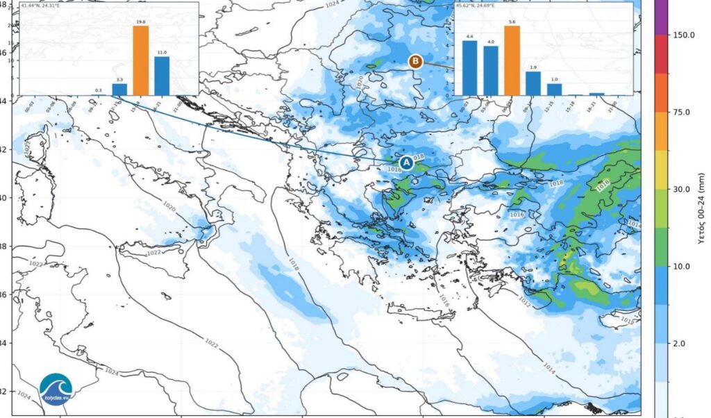
A new atmospheric disturbance is expected to affect weather conditions in Greece toward the end of the week, bringing rainfall mainly to the eastern and northern regions. Meteorologist Theodoros Kolydas has weighed in on the latest forecast data, stressing that, based on current information, there is no indication of a widespread extreme weather event.
Kolydas: What the ICON-EU maps show about the incoming rainfall
As Theodoros Kolydas puts it, “a new disturbance is on the horizon — but that is no reason for panic,” emphasizing that forecast data indicates a new low-pressure system will affect the country toward the end of the week.
Theodoros Kolydas’s full post
Meteorologist Theodoros Kolydas stated in detail:
A new disturbance on the horizon — but no reason for panic.
Yes, the forecast data does show that a new atmospheric disturbance will affect us toward the end of the week, with rainfall expected mainly in the eastern and northern regions. But we shouldn’t turn every autumn shower into a threat or every low-pressure system into an “imminent catastrophe.”
The maps show numbers, not screaming headlines. According to the current ICON-EU forecast, the 24-hour maximum rainfall totals identified over Greek territory are approximately 35mm on Friday and 18mm on Saturday. Based on today’s data, we are not talking about any kind of widespread extreme weather event.
Of course, we will continue to monitor developments and will flag any localized risks that may emerge. Meteorology is not a competition for dramatic effect. Our role is to inform the public in a timely and responsible manner — not to cultivate fear in order to gain a few extra clicks.
🎯ΝEA ΔΙΑΤΑΡΑΧΗ ΣΤΟΝ ΟΡΙΖΟΝΤΑ . OXI ΟΜΩΣ ΚΑΙ ΝΕΟΣ ΛΟΓΟΣ ΓΙΑ ΠΑΝΙΚΟ !
✅Ναι, τα προγνωστικά στοιχεία δείχνουν ότι μια νέα ατμοσφαιρική διαταραχή θα μας απασχολήσει προς το τέλος της εβδομάδας, με βροχές κυρίως στα ανατολικά και βόρεια. Αλλά ας μη μετατρέπουμε κάθε φθινοπωρινή… pic.twitter.com/ncXl5W6VCr— Theodoros Kolydas (@KolydasT) October 14, 2026