
Meteorologist Thodoris Kolydas is describing the current weather event as a heatwave, warning that conditions will peak on Monday (20/7) and Tuesday, with temperatures remaining dangerously high into Wednesday before the pattern begins to shift. The heatwave is expected to hit hardest across eastern and central mainland Greece, Thessaly, eastern Sterea, parts of the Peloponnese, and areas of Attica. According to the meteorologist, temperatures will reach or exceed 40 degrees Celsius.
Read also: Greece weather: New heatwave begins as temperatures set to hit 43°C – which areas are on red alert and when will it cool down (Video)
Thodoris Kolydas’s forecast update
“The evolution of the heat wave across Greece. The three-day outlook from Monday to Wednesday makes it clear that we are not simply dealing with a ‘warm spell,’ but a genuine heat episode with heatwave characteristics, particularly across the mainland. The peak appears to be arriving on Monday and Tuesday, while Wednesday shows a slight easing in the upper-level heat mass — though not enough to signal an immediate end to the episode in most areas.
At 850 hPa, the very warm air mass remains firmly established over the eastern Mediterranean and Greece. On Monday and Tuesday, the hot air advection is more organized, with the highest temperatures favoring the eastern and central mainland, Thessaly, eastern Sterea, parts of the Peloponnese, and locally in Attica. In these areas, maximum temperatures could reach or exceed 40°C, especially where a downslope component or weak sea influence is present.
Wednesday requires careful interpretation. Although a relative easing in the upper-level heat mass appears likely, surface heat will not retreat immediately. The ground will already be intensely heated, minimum temperatures will remain elevated in many areas, and the heatwave — in practical terms of thermal stress — will continue across most inland regions. A meaningful retreat looks more probable from Thursday onward, when a more northerly flow and the gradual replacement of the very warm air mass will begin to bring temperatures down more noticeably, first across the north and east, then progressively further south. A more detailed analysis will follow after midday.”
🎯 Η ΕΞΕΛΙΞΗ ΤΟΥ ΘΕΡΜΟΥ ΚΥΜΑΤΟΣ ΣΤΗΝ ΕΛΛΑΔΑ
✅Η εικόνα του τριημέρου Δευτέρα–Τετάρτη δείχνει ότι δεν έχουμε απλή «ζεστή περίοδο», αλλά θερμό επεισόδιο με χαρακτηριστικά καύσωνα, κυρίως στα ηπειρωτικά. Η κορύφωση φαίνεται να έρχεται τη Δευτέρα και την Τρίτη, ενώ η Τετάρτη… pic.twitter.com/VVwZS8Rfzs— Theodoros Kolydas (@KolydasT) July 19, 2026
Today’s weather
Generally clear skies are expected today, according to the Hellenic National Meteorological Service (EMY), with temporary cloud build-up during the midday and afternoon hours over the mainland. Isolated showers are forecast in mountainous areas, with the possibility of isolated thunderstorms over the mountains of central and eastern Macedonia. Winds in the west and north will be variable at 2–4 Beaufort, while the rest of the country will see northerly winds at 3–5 Beaufort, with locally gusting to 6 Beaufort in the Aegean. Temperatures will reach 33°C in the Cyclades, 35–37°C across the remaining island regions, 38–39°C on the mainland, and locally up to 40°C.
The weather forecast for the days ahead
Monday’s weather forecast
Mostly sunny conditions with temporary cloud cover during the midday and afternoon hours over the mainland, where isolated showers are expected in mountainous areas. There is also a possibility of isolated thunderstorms over the northeastern mountains. Winds will blow from northerly directions at 3–5 Beaufort, with locally 6 Beaufort in the Aegean from the afternoon onward.
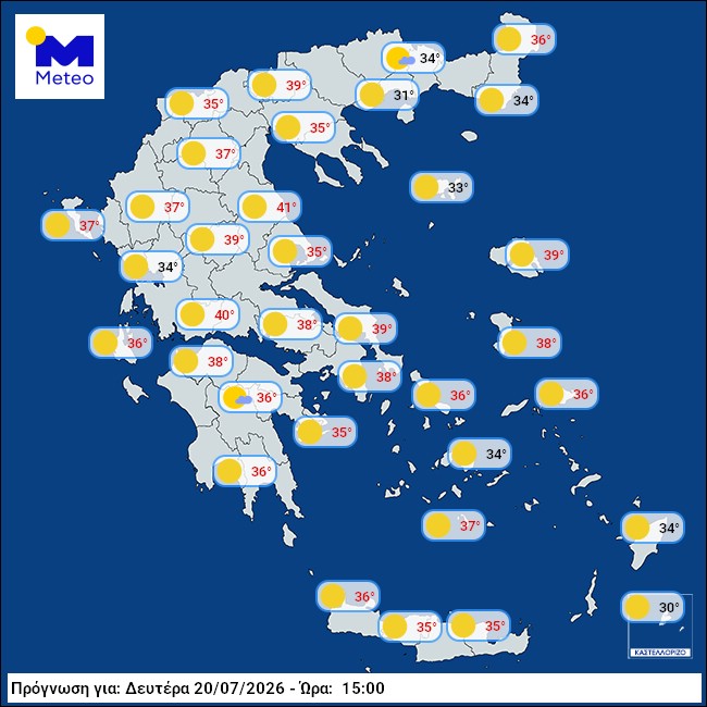
Temperatures will remain at high levels. Highs will reach 33–34°C in the Cyclades, 35–37°C across the rest of the island regions, and 38–39°C on the mainland, with local peaks of 40–41°C.
The Meteo weather map for Monday:
Tuesday’s weather forecast
Mostly sunny with temporary cloud build-up during the midday and afternoon hours, mainly over the central and northern mainland, where isolated showers are expected in mountainous areas. Isolated thunderstorms may develop through the evening hours across central and eastern Macedonia and Thrace. Partial transport of Saharan dust is likely, mainly in the west. Winds will blow from northerly directions at 3–5 Beaufort, with locally 6 Beaufort in the Aegean.
Temperatures will remain at high levels, reaching 33–34°C in the Cyclades, 35–37°C across the remaining island regions, and 38–39°C on the mainland, with local peaks of 40–41°C.
Wednesday’s weather forecast
In the north and gradually the central mainland, partly cloudy skies with local rain or showers and isolated thunderstorms mainly in the north. These weather phenomena will gradually weaken from late afternoon onward. The rest of the country will see mostly sunny conditions with temporary cloud cover during the midday and afternoon hours over the mainland, where local rain or showers may occur over the mountains of Epirus and western Sterea.
Temporary partial transport of Saharan dust is expected. Winds will blow from northerly directions at 3–5 Beaufort, with locally 6 Beaufort over open seas. Temperatures will drop in the north, but will remain high across the southern mainland and southern island regions.
Heatwave map: track the evolution of the phenomenon
View the interactive map tracking the development of the heatwave HERE