
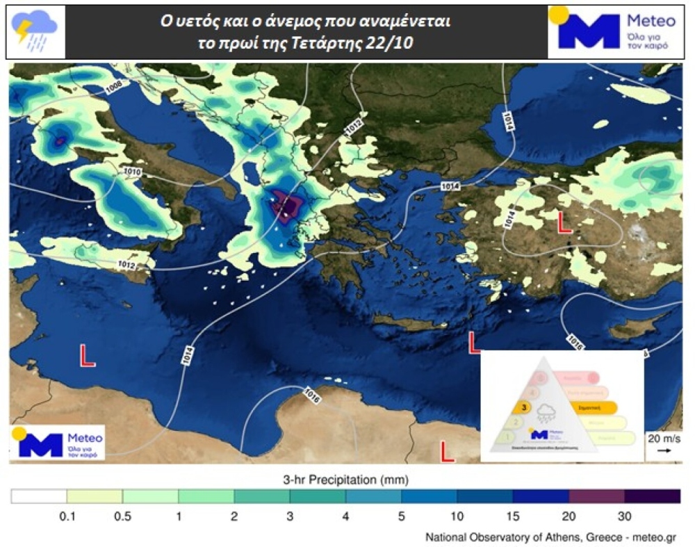
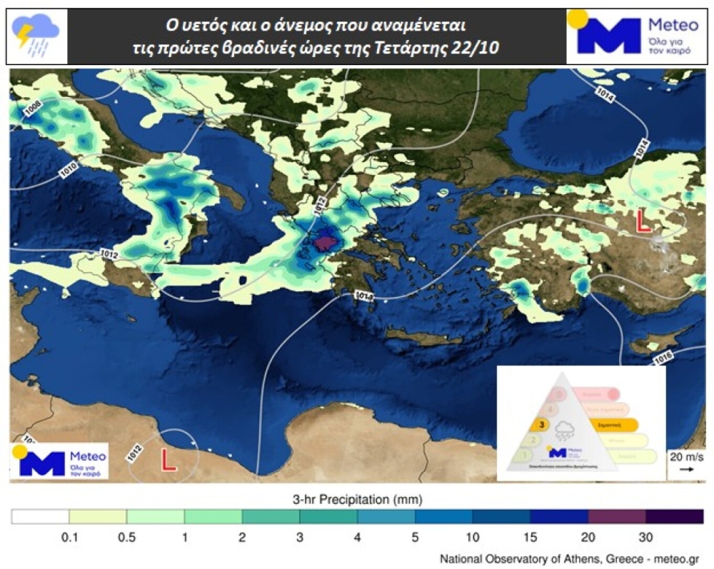
According to the latest forecasts from meteo.gr / National Observatory of Athens, severe weather phenomena are expected from the early hours of Wednesday until Thursday morning (October 23). The phenomena will begin in the Ionian Sea and Epirus and gradually extend to the southern Ionian, western Central Greece, and western Peloponnese. Rain and thunderstorms may be particularly intense locally, mainly in the western mainland and island areas. Additionally, there is a possibility of severe phenomena in the eastern Aegean islands on Thursday afternoon and evening.
Based on the Regional Precipitation Index categorization, this specific episode is classified as Category 3 – “Significant”.
The related maps show the expected rainfall and wind for Wednesday morning and early evening hours.
Today’s weather by region
In the Ionian and western mainland areas, increased cloud cover with rain and scattered thunderstorms, possibly locally strong. In the eastern Aegean islands and Dodecanese, clouds with local showers and mainly in the Dodecanese isolated thunderstorms. In the rest of the country, sparse clouds temporarily denser with brief local showers mainly in mainland areas and the northern Aegean.
Visibility will be locally limited during morning and evening hours, and fog will form locally in mainland areas. Winds will blow from southerly directions 3 to 5 Beaufort.
Temperature without significant change will reach 18 to 21 and locally 22 degrees in western and northern areas, 20 to 24 degrees in other regions, and locally up to 25 degrees Celsius in the Dodecanese and Crete.
MACEDONIA, THRACE
Weather: Clouds periodically increased with local showers and from nighttime scattered thunderstorms in eastern coastal areas.
Winds: From southerly directions 3 to 4 Beaufort.
Temperature: From 09 to 21 degrees Celsius. In western Macedonia 3 to 4 degrees lower.
IONIAN ISLANDS, EPIRUS, WESTERN CENTRAL GREECE, WESTERN PELOPONNESE
Weather: Increased cloud cover with rain and scattered thunderstorms possibly locally strong.
Winds: South-southeasterly 4 to 5 Beaufort.
Temperature: From 13 to 21 and locally 22 degrees Celsius. In the interior of Epirus 3 to 4 degrees lower.
THESSALY, EASTERN CENTRAL GREECE, EVIA, EASTERN PELOPONNESE
Weather: Sparse clouds temporarily denser with brief local showers.
Winds: From southerly directions 3 to 4 and in eastern and southern areas locally 5 Beaufort.
Temperature: From 12 to 24 degrees Celsius.
CYCLADES, CRETE
Weather: Sparse clouds temporarily denser with possibility of brief local showers.
Winds: South-southwesterly 3 to 4 and gradually locally 5 Beaufort.
Temperature: From 16 to 23 and in Crete up to 24 to 25 degrees Celsius.
EASTERN AEGEAN ISLANDS – DODECANESE
Weather: Clouds with local showers and mainly in the Dodecanese isolated thunderstorms.
Winds: From southerly directions 3 to 5 Beaufort.
Temperature: From 13 to 22 and in the Dodecanese from 16 to 24 to 25 degrees Celsius.
ATTICA
Weather: Light clouds temporarily increased with possibility of local showers from afternoon.
Winds: Variable 3 and gradually southerly up to 4 Beaufort.
Temperature: From 14 to 23 degrees Celsius.
THESSALONIKI
Weather: Clouds periodically increased with brief local showers.
Winds: Southeasterly 3 to 4 Beaufort.
Temperature: From 14 to 20 degrees Celsius.
Forecast for Thursday, October 23
In western areas, the Cyclades, eastern and temporarily northern Aegean, clouds with rain and scattered thunderstorms. Weakening of phenomena from afternoon hours. In the rest of the country, clouds locally increased with local showers and improvement from afternoon.
Winds will blow south-southwesterly 3 to 5 and in the Aegean locally 6 Beaufort.
Temperature will show a slight rise. It will reach 20 to 22 and locally 23 degrees in western and northern areas, 23 to 24 degrees in other regions, and locally up to 25 degrees Celsius in the Dodecanese and Crete.
Forecast for Friday, October 24
In the Ionian, western mainland areas, eastern Aegean and Dodecanese, clouds locally increased with local showers and possibly isolated thunderstorms, mainly in northwestern areas. Phenomena will weaken from afternoon.
In the rest of the country, sparse clouds temporarily denser with possibility of weak local showers.
Visibility will be locally limited during morning and evening hours.
Winds will blow from west-southwesterly 4 to 6 and in the Aegean southerly locally up to 7 Beaufort.
Temperature will show a slight further rise.
Forecast for Saturday, October 25
Few clouds, temporarily increased in the Ionian and Epirus where weak local showers may occur.
Visibility will be locally limited during morning hours.
Winds will blow from westerly directions 3 to 5 and in the southern Aegean locally 6 Beaufort.
Temperature will not show significant change.
Forecast for Sunday, October 26
In the Ionian, western and northern mainland areas, increased cloud cover with local showers and possibly isolated thunderstorms.
In the rest of the country, few temporary clouds.
Winds will blow south-southwesterly 4 to 6 and in the Aegean locally 7 Beaufort.
Temperature will show a rise.