
Rain and thunderstorms are coming to hit the country over the next few days, with a new wave of severe weather starting from the western and northern parts of the country and then “visiting” Attica as well, according to the forecast by former Hellenic National Meteorological Service director, Theodoros Kolydas. The Star meteorologist in his post mentions two main disturbances that will affect the country.
When the double weather wave arrives
“The first Thursday to Friday with rain and thunderstorms in the western, central and northern regions (but not in all areas) and the other disturbance Sunday to Monday, which will cause some good rainfall in Athens as well. Temperatures won’t change significantly and remain at levels slightly below normal, while winds will be strengthened on Friday in the Ionian Sea.”
🎯 ΚΑΙΡΙΚΑ ΚΑΙ ΕΠΙΚΑΙΡΑ
✅ Τις επόμενες μέρες περιμένουμε δύο βασικές διαταραχές να μας επηρεάσουν. Η πρώτη Πέμπτη προς Παρασκευή με βροχές και καταιγίδες στα δυτικά τα κεντρικά και Βόρεια (όχι όμως σε όλες τις περιοχές) και η άλλη διαταραχή Κυριακή προς Δευτέρα, που θα… pic.twitter.com/zS4woLWxlX— Theodoros Kolydas (@KolydasT) October 14, 2025
Storm warning: Friday the day with the most intense phenomena, warns Marousakis – Autumn weather scenario continues through the weekend
Autumn, unstable weather with rain as the main characteristic, mainly in western Greece, is forecast by OPEN meteorologist Klearchos Marousakis, who warns that Friday will be the day with the most intense phenomena. According to the meteorologist’s forecast, the scenario remains autumnal until the weekend, with phenomena gradually intensifying day by day. The cause lies in a disturbance in the central Mediterranean, which is moving eastward, bringing rain and thunderstorms.
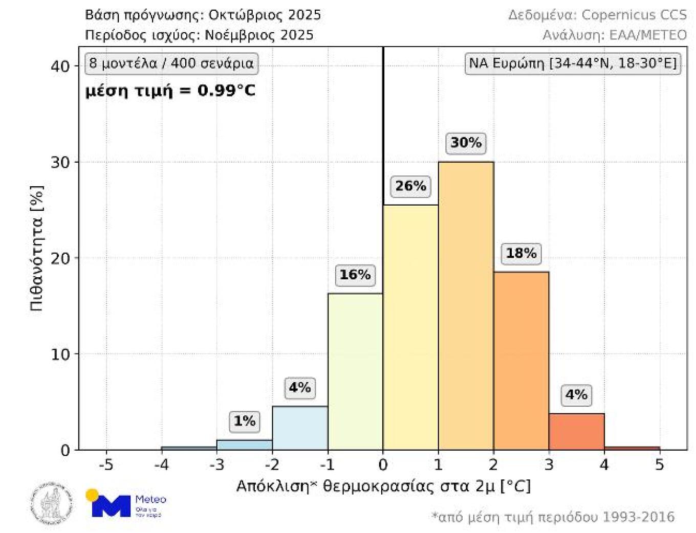
Long-term forecast for November 2025 average temperature
November is expected to be warmer than normal in southeastern Europe (including Greece) according to long-term forecasts issued in early October. As shown in the chart below (Figure 1), according to 78.5% of available scenarios, November’s average temperature will be higher than normal seasonal levels (reference period: 1993-2016). Specifically, the probability for positive deviations between 0 and 1°C, between 1 and 2°C, and above 2°C is 26%, 30%, and 22.5% respectively. The probabilities for negative deviations between 0 and 1°C and above 1°C are 16% and 5.5% respectively. The average value of the 400 scenarios is +0.99°C.
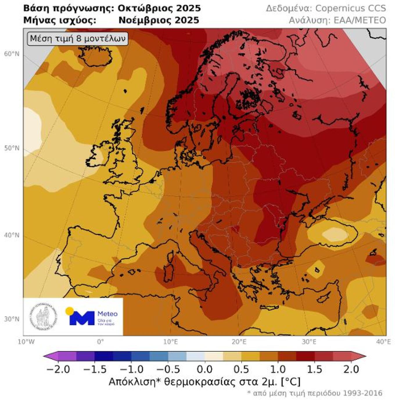
Overall for the European continent, the map in Figure 2 depicts the average temperature deviation for October based on the mean value of the 400 scenarios. As emerges, positive deviations are expected across the entire continent, with the largest values located in eastern and mainly northeastern Europe where they exceed +1°C.
This forecast is based on a total of 400 possible scenarios from the following 8 forecast centers: ECMWF (Europe), UKMO (United Kingdom), Meteo-France (France), JMA (Japan), NCEP (USA), DWD (Germany), CMCC (Italy) and BOM (Australia), as provided by the Copernicus Climate Change Service of the European Commission. It is emphasized that long-term forecasts are characterized by great uncertainty and aim to assess the trend in monthly and seasonal evolution of average weather conditions. Additionally, temperature deviations on a daily and local basis due to the influence of all kinds of weather systems may differ significantly from the average deviation of a month in a broader area.
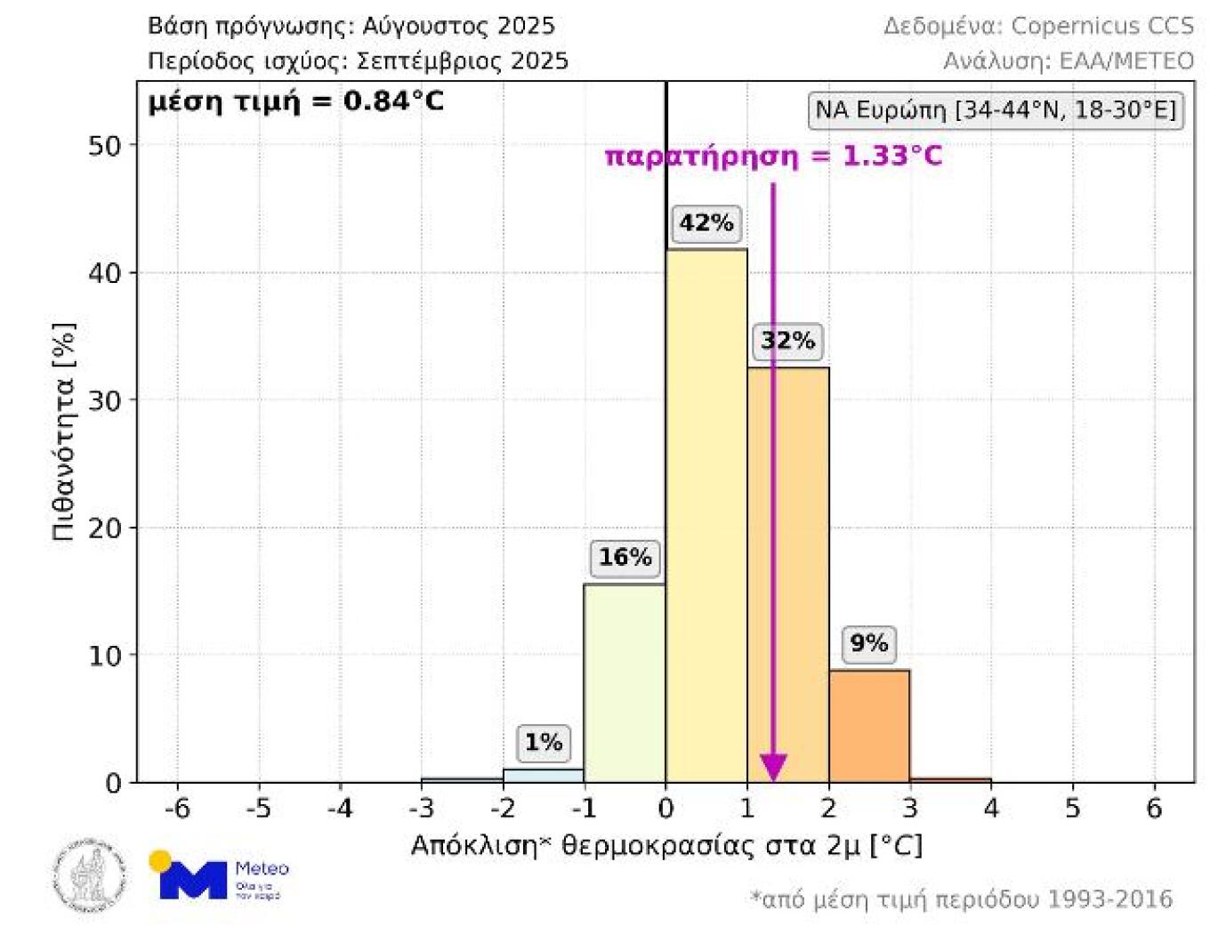
Forecast evaluation for September 2025 average temperature
Regarding last September, the average temperature deviation in southeastern Europe was +1.33°C, while the mean value of all scenarios from the long-term forecast issued in August 2025 was +0.84°C. As shown in the chart below (Figure 3), the magnitude of the observed deviation had a 32% probability and was the 2nd most likely value range in the long-term forecast.
Today’s weather
Clouds with local showers are forecast for the southern Ionian Sea, eastern mainland areas, Evia, Crete, and in the afternoon in mountainous mainland areas. During the night and early morning, visibility will be locally limited and fog will form over the mainland.
Temperature will range in western Macedonia from 4 to 17 degrees, in the rest of Macedonia and Thrace from 8 to 20, in Thessaly from 10 to 22 degrees, in Epirus from 8 to 21 degrees, in the rest of the mainland from 10 to 23, in the Ionian islands from 12 to 21, in the Aegean islands from 12 to 22 (in the Dodecanese up to 24) and in Crete from 10 to 23 degrees Celsius.
Winds will be variable and light, in the Aegean they will blow from northeastern directions and in the southeastern Aegean from northwestern, with intensities 3 to 4 Beaufort.
In Attica, clouds with local showers are forecast mainly in the western parts of the region. Winds will blow from northeastern directions 2 to 4 Beaufort. Temperature will range from 10 to 22 degrees.
In Thessaloniki, increased clouds are forecast. Winds will be variable and light. Temperature will range from 10 to 21 degrees.
Thursday October 16 weather
In the Ionian Sea and mainland areas (except Thrace), clouds temporarily increased with local showers and gradually in the Ionian Sea sporadic thunderstorms. In the evening hours, phenomena in the east will stop, but in the west they will intensify. In the rest of the country, few clouds temporarily increased in Thrace, the Sporades and the mountains of Crete.
Winds will blow in the west from eastern-southeastern directions 4 to 5 and in the Ionian Sea 6 and from evening hours 7 Beaufort. In the east they will blow from northern-northeastern directions 3 to 5 Beaufort.
Temperature will not show significant change. It will reach 18 to 20 in the north, 22 to 24 in the rest of the country and locally in the Dodecanese and southern Crete 25 degrees Celsius.
Friday October 17 weather
In the Ionian Sea, western mainland areas and gradually in central and eastern Macedonia, Thessaly and central mainland Greece as well as in the northern Aegean, clouds temporarily increased with local showers. In the west, sporadic thunderstorms will also develop, which in the Ionian Sea may be temporarily strong. In the rest of the country, few clouds temporarily increased over mainland areas, where a few local showers cannot be ruled out.
Winds in the west will blow from eastern-southeastern directions 4 to 6 and in the Ionian Sea 7 to 8 Beaufort, weakening from midday hours. In the east they will initially blow from northern-northeastern directions 3 to 5 Beaufort and from midday hours gradually from southern-southeastern directions with the same intensity.
Temperature will not show significant change.
Saturday October 18 weather
In the Ionian Sea, western, central and northern mainland areas and in the eastern Aegean islands, unstable weather periodically cloudy with local showers and isolated thunderstorms. In the west, phenomena will gradually weaken and stop in the afternoon. In the rest of the country, few clouds temporarily increased with small probability of weak showers over mainland areas.
Winds will blow in the west from western-northwestern directions 3 to 5 Beaufort. In the east they will blow from southern-southwestern directions 3 to 5 and in the south temporarily locally 6 Beaufort, which from the afternoon will gradually turn to western-northwestern with the same intensity.
Temperature will show a small rise mainly in central and southern areas.
Sunday October 19 weather
Few clouds temporarily increased with local showers in northeastern mainland areas, northern and eastern Aegean islands and gradually in the Ionian Sea and the rest of mainland Greece. Isolated thunderstorms may develop from evening hours in the Ionian Sea.
Winds will blow from eastern-northeastern directions 3 to 5 Beaufort and only in the Dodecanese region northwestern winds 4 to 5 Beaufort will prevail. In the evening hours in the Ionian Sea, winds will turn to eastern-southeastern and strengthen.
Temperature will show a small drop in the north.