
Intense winter extreme weather events and cold air invasions in the age of climate change are at the center of an analysis by Meteo. Atmospheric circulation patterns in the Northern Hemisphere hold the key to understanding why. According to Meteo, there is no doubt that our planet is warming at a rapid pace. Yet powerful cold air invasions continue to occur periodically, triggering significant temperature drops across wide regions. To understand this phenomenon, we need to examine atmospheric circulation in the Northern Hemisphere.
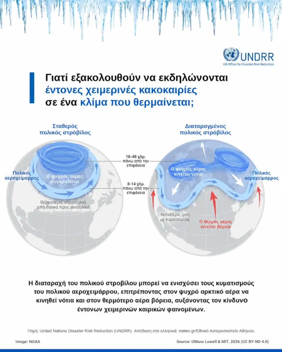
The polar jet stream is a band of extremely powerful winds in the upper troposphere, typically at an altitude of around 8–14 kilometers, blowing predominantly from west to east. The jet stream is closely linked to the large temperature differences between polar regions and lower latitudes, and plays a decisive role in shaping weather patterns. It frequently develops large undulations, or waves, which allow cold air masses to be transported southward and warmer air masses to push northward.
Meteo’s analysis of intense winter storms
When large-scale waves form in atmospheric circulation, extremely cold air masses can reach parts of Europe, Asia, or North America, triggering powerful cold air invasions. Beyond the polar jet stream, the stratospheric polar vortex also plays a significant role — a distinct system of powerful winds that develops during the winter months at much greater altitudes, primarily between 15 and 50 kilometers. In certain cases, disruptions to the stratospheric polar vortex — such as those associated with sudden stratospheric warming events — can influence circulation in the troposphere and favor the development of cold air invasions in specific regions.
Arctic amplification
The Arctic is warming faster than the global average — a phenomenon known as Arctic amplification. This accelerated warming alters the temperature differences between high and mid-latitudes, which can significantly impact atmospheric circulation. Climate change is increasingly associated with a weakening of the polar jet stream and polar vortex, along with a greater tendency for large-scale waves to develop. The result is that cold air of polar origin finds pathways toward lower latitudes, including regions such as southern Europe.
According to the latest assessment by the Intergovernmental Panel on Climate Change (IPCC), extreme cold events have generally decreased in frequency and intensity over recent decades, and are expected to become even less common as global temperatures continue to rise. However, this does not mean that powerful cold air invasions will disappear entirely. The natural variability of atmospheric circulation will continue to produce periods of exceptionally low temperatures, even on a warmer planet.
Ultimately, global warming does not rule out the occurrence of extreme cold. Understanding the mechanisms that drive cold air invasions remains essential for accurate weather forecasting, early warning systems, and the protection of people and infrastructure, Meteo notes in its analysis.


