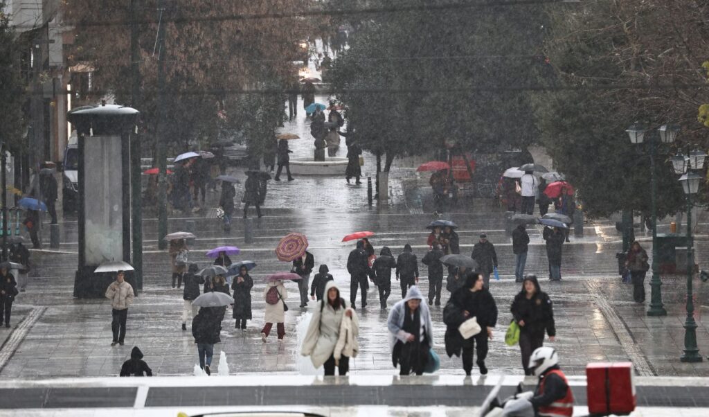
Storm “Deborah” is now advancing into Athens and the broader Attica region, where rain and thunderstorms began affecting many areas of the basin from late Friday afternoon (27/03). The severe weather had already made its appearance in western Greece from the morning, while it entered the capital from midday. More intense phenomena were observed in Malakasa, Vlychada, Elefsina, Aspropyrgos, Aulona, Parnitha, Vilia, and Hippokrateio Politeia, according to meteo reports. However, most areas experienced light rainfall, with precipitation becoming more intense toward the northern suburbs. Weather phenomena may intensify in other areas as well.
How storm “Deborah” will evolve – New wave from April 1st
A new temperature drop is expected until Sunday morning (29/03), as the severe weather will continue to “strike” with rain and thunderstorms. According to meteorologist Giorgos Tsatrafyllias, the highest rainfall amounts are expected to fall in 3 zones over the next 48 hours. Meanwhile, the meteorologist warns of a new strong weather system on April 1st with winter characteristics that will hit the country again.
“The cause of this change is the low-pressure system DEBORAH, which has already formed north of the Adriatic, whose cold front will sweep our country from west to east.
There are three zones of relative danger where most phenomena will occur with increased rainfall amounts.
- 1st zone: western Greece (Friday dawn)
- 2nd zone: Thrace, northern and eastern Aegean (Saturday afternoon-Sunday morning)
- 3rd zone: Crete, southern Cyclades, Dodecanese (Saturday-Sunday morning)
Attica: Will be affected (nothing significant), Friday afternoon-evening.
If the trend of forecast models is confirmed, from Wednesday April 1st, strong severe weather with winter characteristics appears likely,” Giorgos Tsatrafyllias characteristically notes.
Meanwhile, Thodoris Kolydas emphasizes that storm “Deborah” “requires attention,” while warning that from Wednesday (01/04) there appears to be a “more significant deterioration.”
“The low-pressure system named ‘Deborah’ requires attention and in my assessment may cause thunderstorms in Athens tomorrow afternoon. Based on the ENS meteogram for Athens, on Friday 27/3 the maximum possible 6-hour rainfall reaches about 10 to 14 mm, but the most likely scenario is significantly lower, around 2 to 6 mm/6h.
On Wednesday 1/4, the most significant deterioration appears likely, with maximum 6-hour amounts of about 25 to 35 mm, and on Thursday 2/4 also intense phenomena in certain scenarios, with peaks near 30–33 mm/6h,” he noted in his post.
According to Giannis Kallianos, the weather will show temporary improvement on Monday, however from Tuesday a new deterioration is expected that could potentially cause strong rain and thunderstorms, while the new weather system may bring characteristics of a “meteorological bomb.” “In the coming hours and also in the coming days through the weekend, local rain is expected to occur, but this is not something particularly organized or worrying for the entire country. From Monday, the weather appears to show a temporary respite, with limitation of phenomena and quite significant improvement,” he notes.
Watch the storm’s evolution live:
Friday’s weather forecast (27/03)
Clouds temporarily increasing with local rain in most parts of the country. Scattered thunderstorms will occur in the Ionian Sea, mainly in western and northern mainland areas, gradually in the Eastern Aegean islands and Dodecanese, and temporarily in the Cyclades and possibly Crete. Phenomena in western, northern, and eastern Aegean areas may be temporarily strong. In the evening hours, phenomena will be limited to western areas, eastern Macedonia, Thrace, and the eastern Aegean.
Snowfall will occur in mainland mountainous and semi-mountainous areas of Epirus.
Winds will blow from south-southwest 4 to 6 and locally 7 Beaufort with gradual weakening from the afternoon.
Temperature will drop mainly in western and northern areas, reaching 14 to 16 degrees, in other areas 17 to 18, and locally in the Dodecanese 19 degrees Celsius.
Attica
Weather: Clouds temporarily increasing mainly during midday-afternoon hours when rain and scattered thunderstorms will occur.
Winds: South-southwest 4 to 6, in eastern areas up to 7 Beaufort with weakening from the afternoon.
Temperature: From 07 to 16 degrees Celsius.
Thessaloniki
Weather: Increased clouds with rain and scattered thunderstorms. Phenomena may be periodically strong. Gradual improvement from late afternoon.
Winds: Southerly directions 4 to 5 and mainly at midday locally 6 Beaufort.
Temperature: From 07 to 14-15 degrees Celsius.
Macedonia – Thrace
Weather: Increased clouds with rain and scattered thunderstorms. Phenomena may be periodically strong in Macedonia until afternoon and in Thrace from midday. In evening hours, phenomena will be limited to eastern Macedonia and Thrace.
Snow will fall in mountainous areas of Macedonia.
Winds: South-southeast 4 to 5 and in eastern areas locally 6 temporarily up to 7 Beaufort.
Temperature: From 06 to 15-16 degrees Celsius. In western Macedonia 4 to 5 degrees lower.
Ionian Islands – Epirus – Western Central Greece – Western Peloponnese
Weather: Increased clouds with rain and scattered thunderstorms. Phenomena until afternoon may be locally strong.
Snow will fall in mountainous mainland areas and semi-mountainous regions of Epirus.
Winds: Southwest 5 to 7 and locally in southern Ionian up to 8 Beaufort. From afternoon westerly directions 4 to 6 Beaufort.
Temperature: From 06 to 14 degrees Celsius. In interior Epirus 4 to 5 degrees lower.
Thessaly – Eastern Central Greece – Evia – Eastern Peloponnese
Weather: Clouds locally and periodically increasing with rain, scattered thunderstorms and gradual improvement from late afternoon. Phenomena possibly temporarily intense in southern Peloponnese.
Snow will fall in mainland mountainous areas.
Winds: South-southwest 4 to 6 and locally in eastern and southern areas up to 7 Beaufort, with weakening from afternoon.
Temperature: From 06 to 15 degrees Celsius.
Cyclades – Crete
Weather: Few clouds locally and periodically increasing with local rain and temporarily during midday-afternoon hours, mainly in the Cyclades, scattered thunderstorms. Weakening of phenomena from late afternoon.
Winds: South-southwest 5 to 7 Beaufort, with gradual weakening from late afternoon.
Temperature: From 11 to 18 degrees Celsius.
Eastern Aegean Islands – Dodecanese
Weather: Few clouds that will quickly increase and local rain will occur, and from midday scattered thunderstorms. Phenomena in Eastern Aegean islands from afternoon may be locally strong.
Winds: South-southwest 4 to 6, temporarily in northern areas locally 7 Beaufort.
Temperature: From 11 to 19 degrees Celsius.
Weather through Monday
Saturday’s weather 28.03.2026
In western, southern and eastern Aegean areas, increased clouds with local rain and mainly in coastal marine areas periodically isolated thunderstorms. In the rest of the country, few clouds temporarily increasing mainly in northern mainland areas during midday and afternoon hours, when local rain and possibly short-duration thunderstorms will occur.
Snowfall will occur in mainland mountainous areas.
Winds will blow in eastern areas south-southwest and in western areas west-northwest 3 to 5, in central areas and regions of Crete, Cyclades and Dodecanese locally 6 Beaufort.
Temperature will not show significant change and will reach 14 to 16 degrees in western and northern areas, 17 to 18 in other areas, and locally 19 degrees Celsius in the Dodecanese.
Sunday’s weather 29.03.2026
Few clouds temporarily increasing with local rain and periodically until midday in the Ionian, Crete, Cyclades and eastern Aegean isolated thunderstorms, while local showers may occur during midday and afternoon hours in mainland areas. In evening hours, weather will improve in most areas and phenomena will be limited to eastern Macedonia, Thrace and northeastern Aegean islands.
Light snow will fall in mainland mountainous areas until afternoon.
Winds will blow west-northwest 3 to 5, in western and southern seas locally 6 and gradually in southern areas temporarily up to 7 Beaufort.
Temperature will not show significant change.
Monday’s weather 30.03.2026
In eastern Macedonia, Thrace and northeastern Aegean islands temporarily increased clouds with local rain until afternoon. In the rest of the country generally fair weather with few clouds temporarily increasing during midday and afternoon hours, mainly in mainland areas and Crete, where local showers may possibly occur.
Winds will blow west-northwest 3 to 5 Beaufort and from afternoon south-southwest with the same intensity.
Temperature will rise.
There are quite a few mountainous areas that, although March is ending, saw snowfall.