The General Secretariat of Civil Protection is urging citizens to exercise extreme caution and take self-protection measures against risks from severe weather phenomena. Meanwhile, the Ministry of Climate Crisis and Civil Protection has notified relevant state services, regional authorities and municipalities across the country to maintain heightened readiness to address potential impacts from the severe weather. The Fire Service announced the activation of its operational plan for addressing flood risks and associated phenomena.
Fire Services in areas where severe weather phenomena are expected are on high alert status, with the possibility of further escalation if needed, to respond immediately to any problems arising from the impending severe weather.
Detailed recommendations from Civil Protection to citizens
Specifically, in areas where heavy rainfall, thunderstorms or gale-force winds are forecast, Civil Protection advises citizens:
-Secure objects which, if swept away by severe weather phenomena, could cause damage or injuries.
• Ensure that gutters and downspouts of buildings are not blocked and function normally.
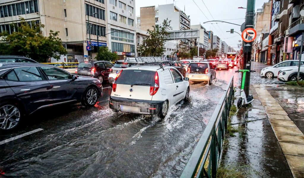
• Avoid crossing torrents and streams, on foot or by vehicle, during storms and rainfall, and for several hours after they end. Particular attention is needed at road network points where the road crosses torrents without bridges.
• Avoid outdoor work and activities in marine and coastal areas during severe weather events (risk from lightning strikes).
• Take immediate shelter during hailstorms.
Seek refuge in a building or car and do not leave the safe space until certain the storm has passed. Hailstorms can be very dangerous for animals too.
• Avoid passing under large trees, suspended signs and generally areas where light objects (e.g. flower pots, broken glass etc.) may detach and fall to the ground (e.g. under balconies).
• Follow strictly the instructions of local authorities, such as Traffic Police etc.
In areas experiencing intense lightning activity:
If you are at home
• Do not handle electrical appliances or telephones as lightning can pass through cables. Disconnect television sets from antennas and electrical power supply.
• Avoid touching plumbing pipes (kitchen, bathroom) as they conduct electricity well.
If you are in a car
• Pull over to the roadside away from trees that might fall on it.
• Stay inside and turn on hazard warning lights until the storm subsides.
• Close windows and do not touch metal objects.
• Avoid flooded roads.
If you are outdoors
• Seek shelter in a building or car, otherwise sit immediately on the ground without lying down.
• Protect yourself under dense branches of low trees if you are in a forest.
• Never shelter under a tall tree in open space.
• Avoid low ground due to flood risk.
• Do not stand near pylons, power transmission lines, telephone lines and fences.
• Do not approach metal objects (e.g. cars, bicycles, camping equipment etc.).
• Move away from rivers, lakes or other water bodies.
• If you are in the sea, get out immediately.
• If you are isolated on flat terrain and feel your hair rising (indicating lightning is imminent), crouch deeply with your head between your legs (to minimize your body surface and ground contact) while discarding any metal objects you carry.
According to the Emergency Weather Deterioration Bulletin issued today by the National Meteorological Service, temporary weather deterioration with heavy rain, thunderstorms and possibly local hailstorms is forecast from tonight (Wednesday 04-02-2026) in northwestern Greece and tomorrow Thursday (05-02-2026) in remaining western Greece regions, northeastern mainland and eastern island areas.
Very strong southerly-southeastern winds of force 8 and locally 9 Beaufort will blow today Wednesday until evening in the Ionian Sea and tomorrow Thursday from morning until afternoon in the Eastern Aegean. Meanwhile, according to meteo.gr / EAA forecasting data, weather will deteriorate again on Thursday 05/02, with rain and thunderstorms that will be locally strong, very strong southerly winds and increased concentrations of African dust.
More specifically:
Rain and thunderstorms will occur from early morning mainly in western and northern parts of the country, gradually extending to most regions, while in the evening they will be limited to Thrace, Eastern Aegean islands and Dodecanese. Phenomena will be locally strong and sometimes accompanied by hail. Areas with highest hail probability are the Ionian Islands, western mainland, Peloponnese, Eastern Aegean islands and Dodecanese.
The rainfall episode, as METEO/EAA emphasizes, is classified as Category 3 (Significant)
Rain will occur periodically in Attica region and Athens city, while thunderstorms are expected mainly during midday and afternoon hours.
Meanwhile, very strong and locally stormy southerly winds will blow in the Aegean.
Atmospheric conditions favor dust transport from Africa and muddy rain occurrence.
The following forecast map shows the cumulative rainfall height expected during Thursday 27/02.
Citizens can stay informed daily about extreme weather developments through regular weather bulletins from the National Meteorological Service and on their website at www.emy.gr, (www.oldportal.emy.gr)
For information and announcements regarding current conditions and road network passability due to floodwater influx or snowfall and frost, citizens can visit the Hellenic Police website www.astynomia.gr.
For more information and self-protection guidelines from severe weather phenomena, citizens can visit the General Secretariat of Civil Protection website at civilprotection.gov.gr
Attached is a relevant METEO/EAA map showing expected cumulative rainfall tomorrow.