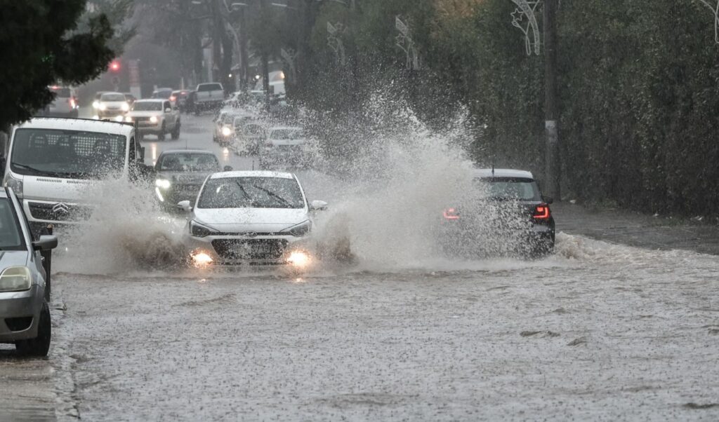
The intense severe weather wave that hit much of the country had particularly serious consequences in Attica. A woman lost her life in Ano Glyfada, while in many areas of the Athens basin roads turned into rivers and streams overflowed, as well as the Kifissos and Ilissos rivers. According to data from the National Observatory of Athens, Attica received the largest amounts of rainfall on Wednesday, with particularly high rainfall recorded both in the Athens basin and in areas of the Eastern Peloponnese and Evia.
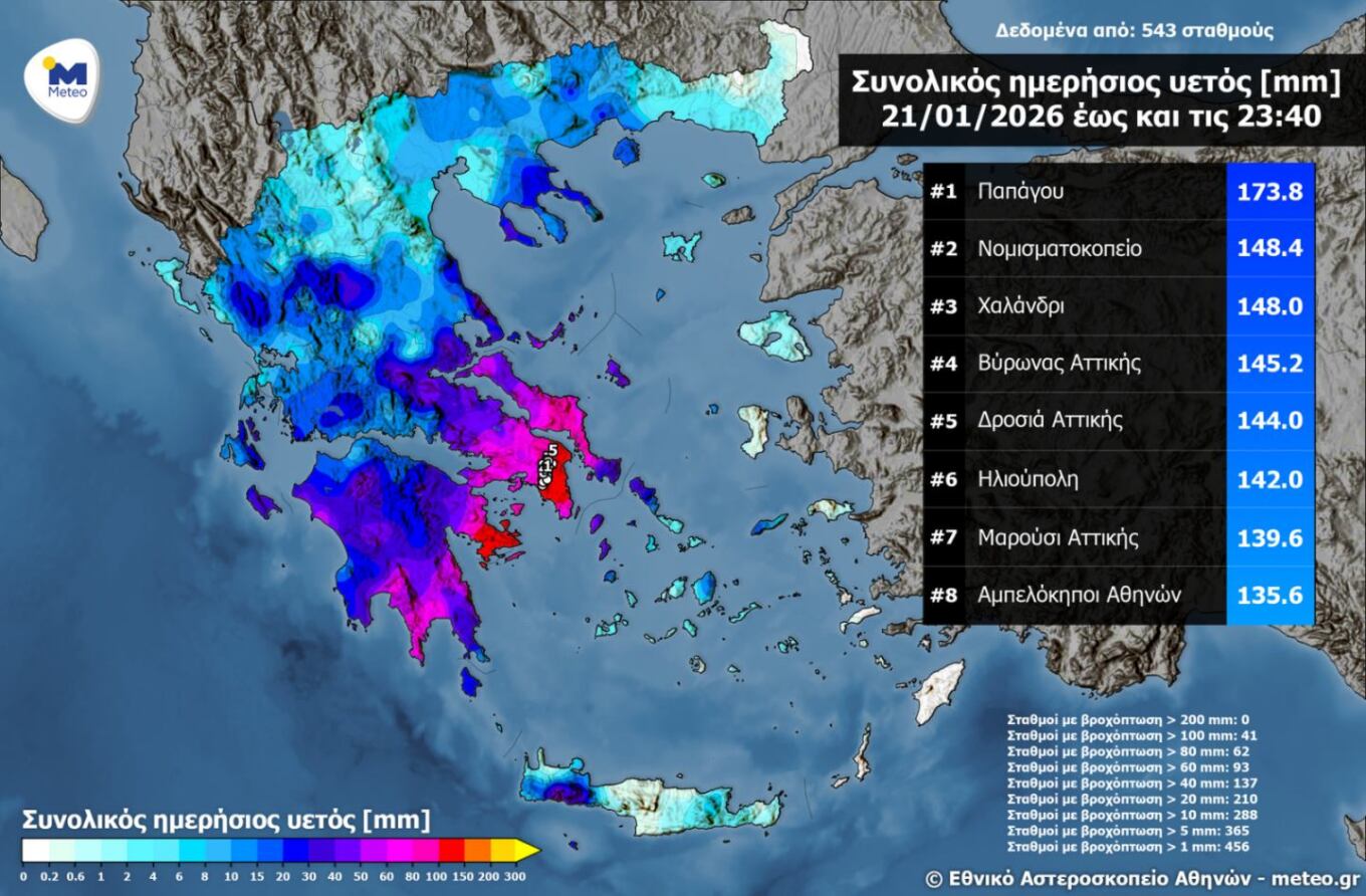
The highest rainfall amounts until Wednesday evening were recorded in Papagos Attica with 173.8 millimeters, at the Mint with 148.4 millimeters, in Halandri with 148 millimeters and in Byron with 145.2 millimeters.
The areas that received the highest volume of water on Wednesday:
- Papagos 173.8 mm
- Mint 148.4 mm
- Halandri 148 mm
- Byron Attica 145.2 mm
- Drosia Attica 144 mm
- Ilioupoli 142 mm
- Maroussi Attica 139.6 mm
- Ampelokipoi Athens 135.6 mm
Two dead, damage and problems from the severe weather
The violent storms that hit the entire country on Wednesday left behind two dead, as well as extensive damage and problems to infrastructure, with Attica at the center of the phenomena. In Ano Glyfada, a 56-year-old woman lost her life yesterday when, while walking, she was swept away by torrential waters and trapped under a vehicle, while in Astros Kynouria, a 53-year-old coast guard officer lost his life in the line of duty, as during an attempt to moor boats at a specific point in the port, a strong wave swept him away, causing him to fall and hit his head.
Risk Assessment Committee convened, Civil Protection on alert due to severe weather – Unsettled weather on Friday
The Risk Assessment Committee convened, in the presence of the Minister of Climate Crisis and Civil Protection, Giannis Kefalogiannis, due to the weather phenomena in progress.
According to the Committee’s scientists, who were convened on the initiative of the General Secretary of Civil Protection, Nikos Papaeustathiou, on Friday the weather will remain unsettled, with thunderstorms occurring mainly in the southern Peloponnese, Cyclades, Crete, eastern Aegean and Dodecanese.
As emphasized by the Ministry of Climate Crisis and Civil Protection in its announcement, the National Coordination Center for Operations and Crisis Management (E.S.K.E.DI.K.) is in constant communication with local and regional authorities, as well as with all involved agencies regarding the evolution of weather phenomena, in order to ensure appropriate operational readiness and response to their consequences.
Today’s weather by region
In the Cyclades, Crete, Dodecanese and islands of the northern and eastern Aegean, increased cloudiness with rain and mainly in the islands of the eastern Aegean and Dodecanese sporadic thunderstorms. In other areas, temporarily increased cloudiness with local rain and in the southern parts of the Peloponnese and isolated thunderstorms.
Visibility will be locally limited on the mainland during morning and evening hours and fog will form. Winds will blow from southern directions 3 to 5 and temporarily locally in the Aegean up to 6 Beaufort.
Temperature will rise slightly in the north. It will reach 12 to 13 degrees in northern mainland areas, 14 to 16 in other areas and 17 to 18 degrees Celsius in the Cyclades, Crete and Dodecanese.
ATTICA
Weather: Cloudiness with local rain early in the morning and again from late afternoon mainly in the southern and eastern parts of the region.
Winds: Variable 3 and in the east from southern directions up to 4 Beaufort.
Temperature: From 07 to 15 degrees Celsius.
THESSALONIKI
Weather: Few clouds.
Winds: Variable 2 to 3 Beaufort.
Temperature: From 05 to 11 degrees Celsius.
MACEDONIA, THRACE
Weather: In Macedonia and Thrace cloudiness with local rain mainly in the east while in Thrace isolated thunderstorms will also occur. Gradually the weather will improve.
Winds: Variable 2 to 4 Beaufort and in Thrace northeastern with the same intensity.
Temperature: From 01 to 13 degrees Celsius. In western Macedonia the maximum 3 to 4 degrees lower.
IONIAN ISLANDS, EPIRUS, WESTERN CENTRAL GREECE, WESTERN PELOPONNESE
Weather: Temporarily increased cloudiness with local rain. Isolated thunderstorms will occur mainly noon-afternoon in the southern Peloponnese.
Winds: Variable 3 to 4 and in maritime-coastal areas from southern directions with the same intensity.
Temperature: From 07 to 16 degrees Celsius. In the interior of Epirus 3 to 5 degrees lower.
THESSALY, EASTERN CENTRAL GREECE, EVIA, EASTERN PELOPONNESE
Weather: Temporarily increased cloudiness with local rain. Isolated thunderstorms will occur in the southern Peloponnese.
Winds: In the north variable 3 to 4 Beaufort and in Sporades until noon northwestern up to 4 Beaufort. In the south southern southwestern 4 to 5 Beaufort.
Temperature: From 04 to 16 degrees Celsius. In the north the maximum 2 to 3 degrees lower.
CYCLADES, CRETE
Weather: Temporarily increased cloudiness with local rain. From midday hours sporadic thunderstorms will also occur. In the evening the weather will improve.
Winds: Southern southwestern 4 to 6 Beaufort.
Temperature: From 12 to 18 degrees Celsius.
EASTERN AEGEAN ISLANDS – DODECANESE
Weather: Cloudiness with rain and sporadic thunderstorms at intervals.
Winds: Southern southwestern 4 to 5 and in the south locally 6 Beaufort.
Temperature: From 11 to 19 degrees Celsius. In the north the maximum 3 to 4 degrees lower.
Saturday’s weather
In the west and eastern Aegean increased cloudiness with local rain and at intervals isolated thunderstorms. In other areas few clouds temporarily increased with weak local rain. Light snowfall will occur from afternoon in the mountains of Epirus and western Macedonia.
Winds will blow southern southwestern 3 to 5 Beaufort with strengthening at night. Temperature will not show significant change and will reach 14 degrees in the north, 15 to 17 degrees in other mainland areas and 18 to 19 degrees Celsius in island areas.
Sunday’s weather
In the west and north increased cloudiness with rain and from noon sporadic thunderstorms which in the west may be locally strong. In the rest of the country few clouds temporarily increased with weak local rain and in the islands of the eastern Aegean and Dodecanese in morning hours isolated thunderstorms.
Light snowfall will occur in the north and from evening also in central mainland mountains, intensifying at night. Winds will blow from southern directions in the west 6 to 7 and in the Ionian 7 to 8 Beaufort. In the east 5 to 6, from afternoon 6 to 7 and in the Aegean locally 8 Beaufort. Temperature will rise.
Monday’s weather
Cloudiness with local rain and sporadic thunderstorms in most of the country. Phenomena in the west, north and eastern Aegean may be locally strong. Snowfall will occur in mainland mountains and Crete. Winds will blow from southern directions 5 to 7 and in the Aegean locally 8 and possibly up to 9 Beaufort. Temperature will drop slightly.
Tuesday’s weather
In central, southern and eastern Aegean areas increased cloudiness with rain and sporadic thunderstorms. In the rest of the country few clouds at intervals increased. Light snowfall will occur in mainland mountains and Crete until afternoon. Winds will blow western southwestern 5 to 6 and in open seas locally 7 Beaufort. Temperature will not show significant change.
New severe weather wave from Sunday predicts Klearchos Marousakis
According to Klearchos Marousakis, today, Friday, the situation will normalize. We expect unsettled weather with rain and thunderstorms in southern southeastern coastal areas, especially towards the southeastern Aegean. Saturday we will have phenomena towards western Greece and the Eastern Aegean islands, while on Sunday, the day will start with mild weather conditions, but a “new severe weather wave” is coming that will bring rain initially to Western Greece and in the following days to the east as well.