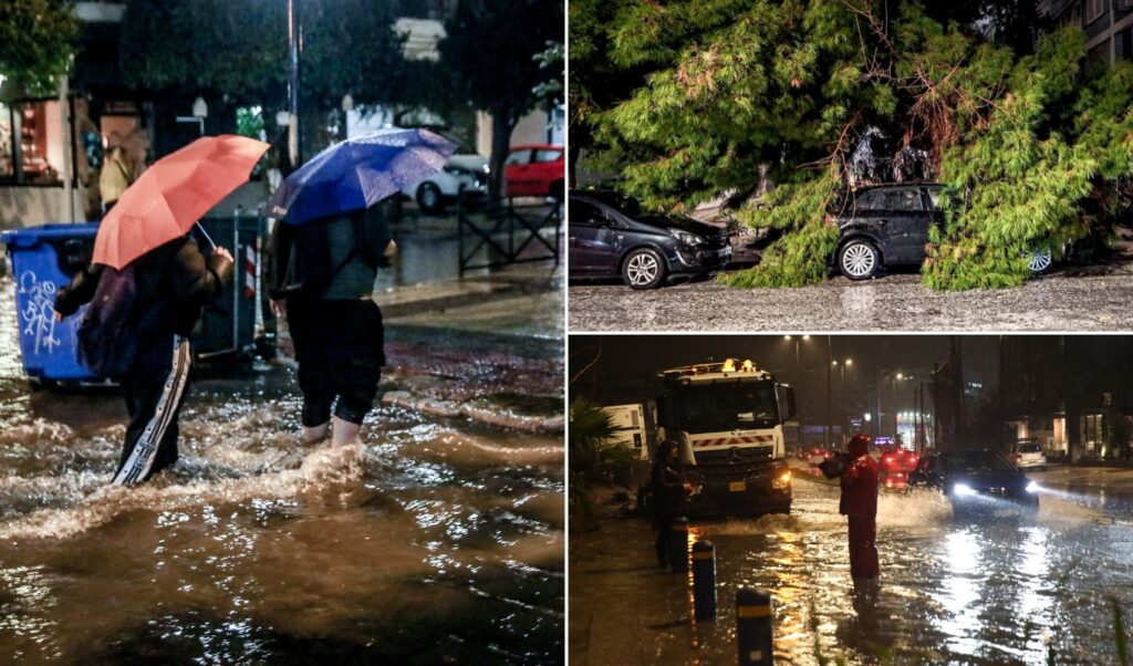
The severe storm battering the country has proven deadly, with two people losing their lives while dozens of areas face serious problems including floods and blocked road networks. Heavy rainfall, gale-force winds, and snowfall, primarily in northern and mountainous parts of Greece, have caused significant disruption to daily life, power outages, and traffic problems, with authorities remaining on high alert.
Read: Weather: Stormy winds, rain and thunderstorms persist through Thursday (Video)
The severe weather system that struck Attica and much of the country, leaving two dead in its wake, is expected to move eastward in the coming hours, with phenomena gradually weakening from Thursday afternoon.
According to the National Meteorological Service, intense weather phenomena will continue in the Eastern Aegean, with heavy rains and thunderstorms in the North and East Aegean islands until midday hours and in the Dodecanese until noon, accompanied by gale-force winds. In western areas, the Peloponnese, Cyclades, Crete, Dodecanese, northern and eastern Aegean islands, and until morning hours in eastern Macedonia and Thrace, cloudy skies with rain and scattered thunderstorms are expected. The phenomena will be intense in the northern and eastern Aegean islands until midday and in the Dodecanese until noon.
In other areas, temporarily increased cloudiness with local rain and isolated thunderstorms will occur.
Temporary snowfall will occur in mainland mountainous areas, mainly central and southern regions.
Temperatures will show a slight increase. They will reach 8-10 degrees in northern mainland areas, 12-14 degrees in other regions, while in Crete, Cyclades and Dodecanese they will reach 17-18 degrees and locally 19 degrees Celsius.
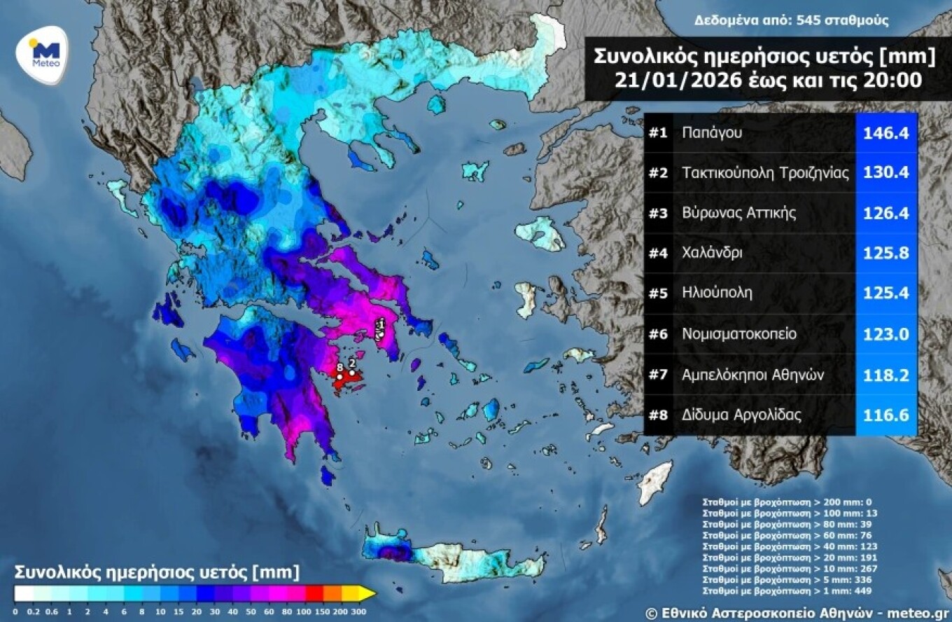
Severe weather in Attica: Highest rainfall recorded in Papagou, Taktikoypoli and Vyronas
Attica once again found itself at the center of severe weather, with intense rainfall starting from Wednesday morning and continuing throughout the day, showing intermittent fluctuations in intensity.
According to data from the automatic meteorological station network of the National Observatory of Athens / Meteo.gr, the highest rainfall amounts by 20:00 were recorded in Papagou, Attica with 146.4 millimeters, followed by Taktikoypoli, Troizinia with 130.4 millimeters and Vyronas, Attica with 126.4 millimeters.
It should be noted that today, both in central Athens and suburbs, rain will continue for most of the day, with rainfall intensifying periodically throughout the entire day. Characteristically, thunderstorms will occur from 05:00 to 08:00 and from 17:00 to 23:00.
Today’s weather by region
Severe weather is forecast in the Eastern Aegean with heavy rain and thunderstorms until midday in the North and East Aegean islands and until noon in the Dodecanese, accompanied by very strong gale-force winds.
In western areas, the Peloponnese, Cyclades, Crete, Dodecanese, northern and eastern Aegean islands, and until morning hours in eastern Macedonia and Thrace, cloudy conditions with rain and scattered thunderstorms. The phenomena will be intense in the northern and eastern Aegean islands until midday and in the Dodecanese until noon.
In other areas, temporarily increased cloudiness with local rain and isolated thunderstorms.
Temporary snowfall will occur in mainland mountainous areas, mainly central and southern regions.
Temperatures will show a slight increase, reaching 8-10 degrees in northern mainland areas, 12-14 degrees in other regions, while in Crete, Cyclades and Dodecanese they will reach 17-18 degrees and locally 19 degrees Celsius.
MACEDONIA, THRACE
Weather: Cloudiness in eastern Macedonia and Thrace, mainly in coastal areas with local rain or sleet and scattered thunderstorms. Phenomena in eastern Macedonia will quickly stop and be limited to the easternmost parts of Thrace. Snowfall will occur locally in mountainous areas until early morning hours.
Winds: In western areas easterly-northeasterly 4-6 Beaufort, in eastern areas from northern directions 3-5 Beaufort. From afternoon, variable 3-4 Beaufort.
Temperature: From 1 to 9 degrees Celsius. In western Macedonia, maximum temperatures 3-4 degrees lower.
IONIAN ISLANDS, EPIRUS, WESTERN CENTRAL GREECE, WESTERN PELOPONNESE
Weather: In Epirus, cloudiness with possibility of local rain. In other areas, increased cloudiness with local rain and scattered thunderstorms. Snowfall will occur locally in mountainous areas until noon.
Winds: In northern areas southerly-southeasterly 4-6 Beaufort, in southern areas southwesterly with same intensity. From noon, gradually weakening to 3-5 Beaufort, turning to westerly-northwesterly in southern areas.
Temperature: From 7 to 14 degrees Celsius. In Epirus, 3-5 degrees lower.
THESSALY, EASTERN CENTRAL GREECE, EVIA, EASTERN PELOPONNESE
Weather: In Thessaly and Sporades, local cloudiness. In other areas, increased cloudiness with local rain and scattered thunderstorms, initially in eastern Peloponnese and from afternoon in eastern Central Greece. Snowfall will occur locally in mountainous areas of eastern Peloponnese until morning hours.
Winds: In northern areas northwesterly 3-5 Beaufort, from noon variable 3-4 Beaufort. In southern areas southerly-southwesterly 4-6 Beaufort.
Temperature: From 4 to 15 degrees Celsius. In northern areas, maximum temperatures 3-4 degrees lower.
CYCLADES, CRETE
Weather: Increased cloudiness with local rain and scattered thunderstorms.
Winds: Southerly-southwesterly 5-7 Beaufort, until morning in eastern areas southeasterly 8-9 Beaufort.
Temperature: From 12 to 17 degrees Celsius.
EASTERN AEGEAN ISLANDS – DODECANESE
Weather: Cloudiness with local rain and scattered thunderstorms. Phenomena will be particularly intense in eastern Aegean islands until midday and in Dodecanese until noon.
Winds: Southerly-southeasterly, in northern areas 6-8 Beaufort quickly turning to southerly-southwesterly 4-6 Beaufort, in southern areas 8-10 Beaufort gradually turning to southerly-southwesterly and weakening from midday hours.
Temperature: From 11 to 19 degrees Celsius. In northern areas, maximum temperatures 3-4 degrees lower.
ATTICA
Weather: Cloudiness gradually increasing with local rain after noon.
Winds: Initially variable 3-4 Beaufort, gradually turning from southern directions 3-5 Beaufort.
Temperature: From 7 to 15 degrees Celsius.
THESSALONIKI
Weather: Cloudiness, temporarily increased.
Winds: Northerly-northwesterly 3-4 Beaufort, from noon variable light winds.
Temperature: From 3 to 9 degrees Celsius.
Schools remain closed Thursday due to severe weather
Several schools across various regions will remain closed on Thursday (22/1) as severe weather continues causing problems, mainly in Northern Greece and island areas. Related decisions are made by municipal authorities prioritizing student and teacher safety.
In Attica, however, schools will operate normally as announced by the Attica Region, since weather conditions do not create obstacles for conducting classes.
The Municipality of Lagkadas announced that tomorrow, Thursday, all schools of all levels, as well as kindergartens and day care centers, will operate normally. The exception is the municipal unit of Lachana, where schools will remain closed for another day due to continuing heavy snowfall.
In the Municipality of Servion, Kozani, by mayoral decision, operation of all primary and secondary education schools is suspended. Kindergartens and nurseries will operate normally without schedule changes. Conversely, in Kozani Municipality, all schools and kindergartens will remain open.
In Florina Municipality, schools will open with delay at 9:15 a.m., while kindergartens will operate normally. In Prespa Municipality, classes will start one hour later, with day care and kindergarten operating without changes.
In Kastoria Municipality, primary and secondary schools will start at 9:00 a.m. Kindergartens, nurseries and day care will remain open, with situation reassessment Thursday morning.
In Nestorio Municipality, schools will open at 9:00 a.m., as will primary and secondary schools and vocational training centers in Argos Orestiko Municipality. Nurseries, kindergartens and day care will operate normally.
Schools closed in Mytilene, Chios and Samos
By decisions of mayors in Mytilene, Chios, and East and West Samos municipalities, all schools will remain closed Thursday. The suspension affects both schools and nurseries due to adverse weather conditions prevailing in these areas.
Emergency alert 112 issued
Emergency alert 112 was sent to Rafina, calling residents near the Megalos Rema estuary to head toward the city hall due to stream overflow. Earlier, residents in Gkorytsas, Aspropyrgos received messages due to Agios Ioannis stream overflow, as did those in North Aegean Region to limit movements.
⚠️ Emergency Alert 1️⃣1️⃣2️⃣
🆘 If near Megalos Rema estuary in Rafina, East Attica, head toward Rafina City Hall due to stream overflow
‼️ Follow authorities’ instructions.
— 112 Greece (@112Greece) January 21, 2026
⚠️ Emergency Alert 1️⃣1️⃣2️⃣
🆘 If in Gkorytsas area, Aspropyrgos, West Attica, move toward Genoktonias area due to Agios Ioannis stream overflow
‼️ Follow authorities’ instructions.
— 112 Greece (@112Greece) January 21, 2026
⚠️ Emergency Alert 1️⃣1️⃣2️⃣
🆘 Due to severe weather expected in North Aegean Region from tonight until Thursday noon 22-01-26, limit movements to absolutely necessary.
‼️ Follow authorities’ instructions.
ℹ️…
— 112 Greece (@112Greece) January 21, 2026
Paralios Astros: 53-year-old coast guard officer found dead
A coast guard officer was found dead after being pulled from the sea following an accident in Paralios Astros. According to reports, the 53-year-old officer was helping secure boats at the harbor to prevent them from being swept away by strong winds when he fell into the sea for unknown reasons. In his effort, he was swept away by waves and hit his head. An alarm was immediately raised, but he was later pulled unconscious and transported to Astros Health Center where his death was confirmed.