
Storm Adel has begun to “hammer” Attica with Vouliagmenis Avenue at the height of Glyfada (towards Athens) experiencing flooding phenomena as you can see in the video below from Parapolitika.gr. Among the areas most affected so far are Ilioupoli, Pallini, Markopoulo and Koropi, where the storm intensity is heightened.
Read: Storm: Asphalt collapses in Tzoumerka – Blow to local economy as cancellations reach 100% (Video)
View this post on Instagram.
Storm Adel: Current traffic conditions
According to traffic police, congestion exists on:
- Athens-Corinth/Athens Avenue (inbound)
- Athens-Lamia (Athens to Kaliftaki junction – outbound)
- Athens-Lamia (Kaliftaki junction to Athens – inbound)
- Kifisou Avenue (southbound)
- Alexandras Avenue
- Mesogeion Avenue
- Katechaki (towards Ilioupoli)
- Kifisias Avenue (northbound)
- Kifisias Avenue (southbound)
- Vasileos Sofias (northbound)
- Vasileos Sofias (southbound)
- Vasileos Konstantinou
- Kallirois
- Syngrou Avenue (northbound)
- Panepistimiou
- Stadiou
- Vasileos Amalias
- Vouliagmenis Avenue
- Piraeus Port
- Poseidonos Avenue (Alimos to Karaiskaki – towards Piraeus)
Delays also occur on Attiki Odos highway.
Delays are located:
Towards Airport:
10′-15′ from Metamorfosi to Kifisias.
Towards Elefsina:
5′-10′ from Plakentias to Kifisias.
10′-15′ at Piraeus exit,
10′-15′ at Fylis exit,
10′-15′ at Dimokratias exit.
Towards Alimos-Karea.
Delays:
towards Airport:
20′-25′ from Fylis to Kifisias.
towards Elefsina:
10′-15′ from Paiania to Marathon.
20′-25′ at Piraeus exit,
10′-15′ at Fylis exit,
10′-15′ at Dimokratias exit.
Delays from Agia Paraskevi to Karea exit. https://t.co/CXGfmGxyg3— Attiki Odos Traffic (@aodostraffic) November 26, 2025
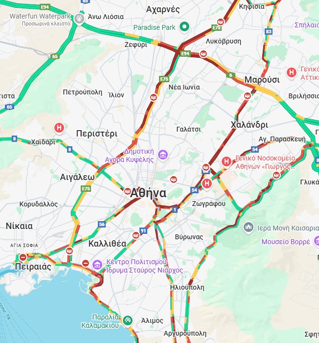
View live traffic HERE
Storm Adel: How weather conditions will develop
Tomorrow Thursday (27/11), severe weather phenomena will manifest in the Ionian islands, Epirus, western and central mainland Greece, western and southern Peloponnese, as well as central and eastern Macedonia and Thrace. Friday forecasts predict heavy rains and thunderstorms in central and eastern Macedonia, Thrace, eastern Aegean, and until early morning in western Greece.
Meteorologist Theodoros Kolydas’ analysis
According to meteorologist Theodoros Kolydas, the storm will “hit” the western part of the country, however areas in Eastern Macedonia and Thrace will also be affected on Friday. As he notes in his post, high rainfall levels will be recorded today, but not at the levels of previous days. A characteristic case is Pramanta in Ioannina which has around 80mm so far today, while last Friday the astronomical amount of 256mm was recorded.
“Storm wave Adel will be very close to Western Greece tomorrow Thursday, moving slowly eastward, feeding moisture and intense phenomena to vulnerable areas in south-southwest flow. Apart from the west, Eastern Macedonia-Thrace will be affected – more on Friday – where the system will move further