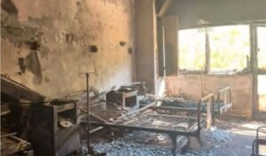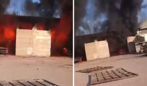
A large part of the country is on high alert for wildfire risk due to the “explosive cocktail” of strong northern winds and heat. The strengthening of northern winds, with gusts reaching up to 9 Beaufort, has put authorities on heightened readiness to respond immediately to any fire incidents.
On Thursday morning, Climate Crisis and Civil Protection Minister Yannis Kefalogiannis convened an inter-ministerial coordination meeting due to the stormy winds. Earlier, the scientific Risk Assessment Committee had met, highlighting the increased fire risk and navigation problems.
According to Risk Assessment Committee scientists, northern winds of 8 Beaufort intensity are forecast, with gusts up to 9, in the Eastern mainland, Central and South Aegean, as well as Crete.
Friday will be the most difficult day with increased wildfire risk and navigation problems. Saturday, wind intensity will reach 7 to 8 Beaufort, while Sunday locally up to 7. Temperature in Western Greece will gradually rise, and over the weekend will reach 38 to 39, and locally 40 degrees. In the east, due to the meltemi winds, temperature will not exceed 35 to 37 degrees.
Stormy northern winds and deteriorating fire weather conditions
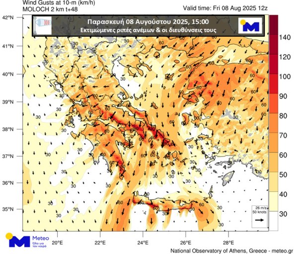
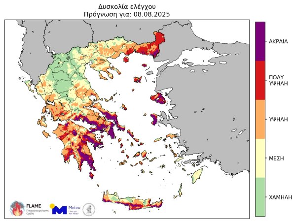
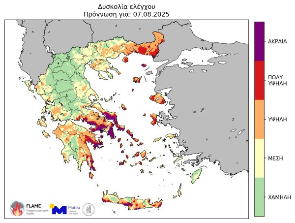
According to forecast data from the National Observatory of Athens / Meteo.gr, wind gusts during Thursday afternoon 07/08 in Eastern Central Greece will reach 80 km/h, while in South Evia, the Cyclades and South Crete they will locally reach 90 km/h. According to available forecast data, Friday 08/08 expects further strengthening of northern winds, with gusts in Eastern Central Greece, South Evia, Cyclades and locally in South Crete reaching 100 km/h, as clearly shown in the map below.
It is noted that due to wind strengthening, fire weather conditions will significantly deteriorate in eastern areas, with main characteristics:
- Very high potential for wind-driven forest fires with potentially high heat loads in eastern and southern areas.
- Significant increase in control difficulty in case of fire ignition in eastern and southern areas, mainly in regions where no rainfall occurred in recent days.
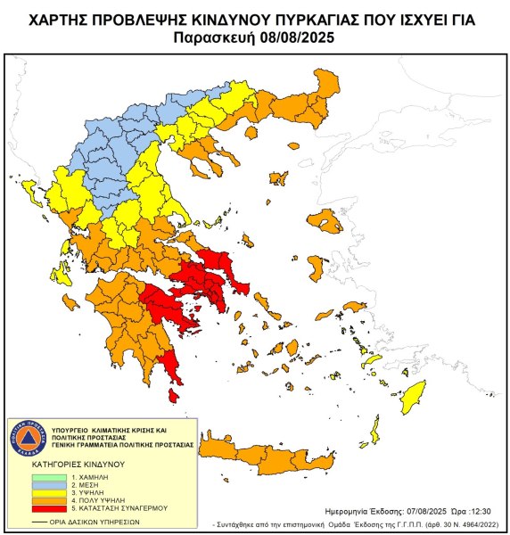
The following map group presents the estimated control difficulty according to the Canadian Forest Fire Weather Index System (CFFWIS), adapted to Greece’s fire environment during Thursday 07/08 and Friday 08/08/2025.
Weather: extreme fire danger, which areas are in the red zone
According to the Fire Risk Forecast Map issued by the General Secretariat of Civil Protection of the Ministry of Climate Crisis & Civil Protection (civilprotection.gov.gr), for tomorrow Friday 08 August 2025, the following is forecast:
Extreme fire danger – Alert Status (risk category 5) for the following areas:
- Attica Region (including Kythera island)
- Central Greece Region (Boeotia, Evia Regional Units)
- Peloponnese Region (Argolida, Corinthia, Laconia Regional Units)
Very high fire danger (risk category 4) for the following areas:
- Western Greece Region
- Peloponnese Region
- Ionian Islands Region (Zakynthos Regional Unit)
- Central Greece Region (Boeotia, Phthiotida, Phocida, Evia Regional Units including Skyros island)
- Thessaly Region (Magnesia Regional Unit)
- North Aegean Region
- South Aegean Region (Cyclades Regional Units)
- Crete Region
- Eastern Macedonia and Thrace Region (Rhodope, Kavala, Thasos, Xanthi, Evros Regional Units including Samothrace island)
- Central Macedonia Region (Chalkidiki Regional Unit, including Mount Athos)
- Epirus Region (Preveza Regional Unit)
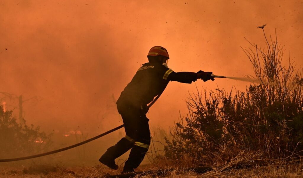
The General Secretariat of Civil Protection (civilprotection.gov.gr) of the Ministry of Climate Crisis & Civil Protection has informed the competent state services involved, as well as the Regions and Municipalities of the above areas, to be in heightened civil protection readiness to respond immediately to any fire incidents.
Additionally, the General Secretariat of Civil Protection advises citizens to be particularly careful and avoid activities in the countryside that could cause fire from negligence, such as burning dry grass and branches or cleaning residues, using machinery that causes sparks like angle grinders, welding devices, using outdoor barbecues, smoking bees, throwing lit cigarettes, etc. It is also reminded that during the fire prevention period, field burning is prohibited.
In case citizens detect a fire, they are requested to immediately notify the Fire Service at emergency number 199.
Weather – Tsatrafyllias: “These dangers bring the meltemi winds – 100 km/h winds bring storms”
The regions of Attica, Central Greece (Boeotia, Evia) and Peloponnese (Argolida, Corinthia, Laconia) will be on red alert from tomorrow, Friday August 8, for the third time this year, for extreme wildfire risk.
The possibility of sailing bans is also open as meteorological forecasts predict wind gusts that could reach up to 8-9 Beaufort at Cape Kafireos.
In a social media post, meteorologist Giorgos Tsatrafyllias warns about dangers that tomorrow’s expected meltemi winds may cause and draws attention from residents and those planning to travel by ship.
Simultaneously, he highlights 5 areas where winds may exceed 100 kilometers/hour and create local storms.
- Cape Doro
- South Euboean Gulf
- Northern Cyclades
- Carpathian Sea
- Western – Southern Crete
Detailed post by Giorgos Tsatrafyllias:
Weather: strong winds up to 9 Beaufort in the Aegean – where temperature will reach 38 degrees
Weather will be generally clear on Friday (8.08.2025) with strong winds up to 9 Beaufort. Temperature will be relatively high throughout the country and will reach 38 degrees Celsius in Western Central Greece. Where there will be clouds and local rain.
According to the National Meteorological Service weather forecast, winds will blow from northern northeast directions, in western areas 4 to 6 and in eastern areas 6 to 7 and in the Aegean 8 locally 9 Beaufort.
Temporary cloud cover will occur in northern Crete and during midday-afternoon hours in the mountains of western and central Macedonia where local showers are possible.
Temperature will not change significantly and will reach 34 to 36 and locally in western mainland areas 37 to 38 degrees, while in the Cyclades, Sporades and northern Crete will not exceed 30 to 31 degrees Celsius.
ATTICA
- Weather: Generally clear.
- Winds: Northern northeast 5 to 7 and in eastern areas locally 8 Beaufort.
- Temperature: From 24 to 34-35 degrees Celsius.
CENTRAL MACEDONIA
- Weather: Generally clear with temporary cloud cover during midday-afternoon hours in the mountains of western and central Macedonia where local showers are possible.
- Winds: Northern northeast 4 to 6 and in eastern sea areas 7 Beaufort.
- Temperature: From 20 to 35 and locally 36 degrees Celsius. In western Macedonia 2 to 3 degrees lower.
THESSALONIKI
- Weather: Generally clear with few clouds early morning and again at midday-afternoon.
- Winds: From northern directions 4 to 5 Beaufort.
- Temperature: From 21 to 34 degrees Celsius.
EASTERN CENTRAL GREECE – EVIA
- Weather: Generally clear.
- Winds: Northern northeast 4 to 6 and in eastern areas 7 locally 8 Beaufort.
- Temperature: From 21 to 35-36 degrees Celsius.
WESTERN CENTRAL GREECE
- Weather: Generally clear with temporary cloud cover during midday-afternoon hours in Epirus mountains.
- Winds: Northern northeast 4 to 5 and in the Ionian locally 6 Beaufort.
- Temperature: From 20 to 34 and in mainland areas locally 37-38 degrees Celsius. In interior Epirus minimum 3 to 4 degrees lower.
EASTERN MACEDONIA
- Weather: Generally clear with temporary cloud cover during midday-afternoon hours in the mountains of western and central Macedonia where local showers are possible.
- Winds: Northern northeast 4 to 6 and in eastern sea areas 7 Beaufort.
- Temperature: From 20 to 35 and locally 36 degrees Celsius. In western Macedonia 2 to 3 degrees lower.